 |
|
  Click to enter. |

|
|
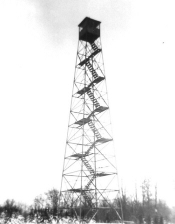
Alander Mt. Fire Tower Location: In the State of Massachusetts about one quarter of a mile east of the New York border.
At the top of Alander Mt., at an elevation of 2240', Conservation Department forest rangers supervised the erection a 60' Aermotor LS40 Aermotor tower. Such cooperation was the norm for the times as State Parks was another Division within the Conservation Department, being placed there in early 1927. Three miles of telephone line were constructed to connect the tower with the New York Telephone system. The tower was intended primarily for spotting fires on the Park. However, arrangements were made with the Park Commission so that fires on State land or private land outside the Park would be reported to the local fire wardens. In August 1930, the Commission received a notice from Mr. William A. Miles, of Salisbury, Conn. terminating the lease to the part of his property currently being used as the site for the fire tower. In response to Mr. Miles notice, the Park had the tower dismantled by the end of the year. The parts were placed in storage at High Valley Farm, the home of Commissioner Francis R. Masters, pending the possible relocation of the tower by the Conservation Department. It was not until 1932 that the Conservation Department agreed to accept the transfer of the tower from the Park Commission. The tower was then erected on private lands on Washburn Mt. in late 1932 and became operational in 1933. The tower remained on Washburn Mountain until 1964 when it was moved to Beebe Hill, where it remains today. |
|
Beebe Hill Fire Tower Location: 2 miles northwest of Austerlitz on the Beebe Hill State Forest.
The tower ceased operation at the end of the 1988 season and was officially closed in early 1989 when the Department of Environmental Conservation determined that fire towers were no longer effective and decided to phase them out of service. In 1997, Beebe Hill Fire Tower was added to the National Historic Lookout Register. Ten years after the closing of the facility, individuals came together to restore the fire tower and observer's cabin so that the public could safely continue to enjoy Beebe Hill for years to come. This group was made up of local residents, NYS-DEC Foresters, NYS-DEC Forest Rangers and members of the Forest Fire Lookout Association.
|
|
Washburn Mt. Fire Tower Location: On private lands, 1 mile southeast of Copake Falls near the New York / Massachusetts border.
The parts were placed in storage at High Valley Farm, the home of Commissioner Francis R. Masters, pending the possible relocation of the tower by the Conservation Department. It was not until 1932 that the Conservation Department agreed to accept the transfer of the tower from the Park Commission. The agreement stated that "the Commission would be glad to consider the transfer of the fire tower to the Conservation Department if the Conservation Department would agree to erect in within three months." In late 1932 the Conservation Department erected the 60" Aermotor tower on private lands on the summit of Washburn Mountain. The tower would remain on Washburn until 1964 when it was moved to Beebe Hill, where it remains today.
|
|
|
|
Bramley Mt. Fire Tower Location: 5 miles east of Delhi
|
|
Rock Rift Fire Tower Location: Tower Mt. about 2 miles northeast of the Hamlet of Rock Rift and north of the Cannonsville Reservoir.
This tower ceased operation at the end of the 1988 season and was officially closed in early 1989 when the Department determined that fire towers were no longer effective and decided to phase them out of service. This tower is currently owned by the Town of Tompkins, and there are plans for restoration underway. It remains on New York City DEP lands but is closed to the public. There is a public trail to the tower. |
|
Twadell Point Fire Tower Location: 1 1/2 mile north of the Hamlet of East Branch
By 1916 each observation station included a cabin for the observers comfort. Previously, most were provided only tents for shelter. These original cabins were usually constructed of logs cut on site. Most were small and less than ideal. In the early 20’s a standard design would be developed. This tower was closed at the end of the 1972 season and was sold to the landowner of the land on which it still stands. Though the tower still remains, it's on private land and is closed to the public.
|
|
Utsayantha Mt. Fire Tower Location: 2 miles southeast of the Village of Stamford
The first and only State structure on Utsayantha was a 59' 3" International Derrick tower erected by the CCC in 1934. The tower was closed at the end of the 1989 season, making it one of the last operating fire towers in New York State. Negotiations were completed in 2003 which allowed for the transfer of ownership of the tower to the Village of Stamford. A group was formed in 2003 to take on restoration of the tower as well as all other improvements on the mountaintop site. Restoration work began in 2004 and was completed in July of 2005 and a dedication held. FFLA worked on the restoration project. |
|
|
|
Beacon Mt. Fire Tower Location: 2 miles east of the City of Beacon.
Historical data collected shows that a major community existed on top of North Beacon through the first half of the twentieth century. Access was gained to the mountaintop by means of an electric inclined railway that operated from 1901 to 1975 during which an estimated 3 million people road the railway to the 1540' summit, where a casino, hotel and numerous cottages existed.
The structure on South Beacon Mt. is a standard 60' Aermotor LS40 tower erected by the Conservation Department in 1931, which became operational in 1932. It is located about 2 miles southeast of the City of Beacon. The tower was established with funds from Dutchess Co and various private sources.
With the advent of aerial detection this tower was closed Beacon Mt. was added to the National Historic Lookout Register in December 2005. The tower still remains and a group has restored andmaintains the tower. You can visit the group's website for more information on the project by clicking here. |
|
Clove Mt. Fire Tower Location: 7 miles south of the Village of Millbrook.
This tower ceased operation at the end of the 1988 season and was officially closed in early 1989 when the Department of Environmental Conservation determined that fire towers were no longer effective and decided to phase them out of service. Though the tower still remains, it's on private lands and is closed to the public. |
|
Stissing Mt. Fire Tower Location: 2 mile west of Pine Plains.
This tower was first staffed in 1935 reporting 91 fire and 610 visitors. The tower is on the northern shoulder of the mountain at 1370' and not on the summit. The summit is 1403'. This tower ceased operation sometime between 1979 and 1982 but still remains. Marked trails take you to the tower. The trail to the right follow the Observer's jeep road and the telephone line. Poles can still be seen along this route. The tower has been restored by Friends of Stissing Landmarks and is open to the public. |
|
|
|
Hunter Mt. Fire Tower Location: 2 miles south of the Hamlet of Hunter.
The Conservation Commission replaced it with a 60' Aermotor LS40 tower in 1917. The tower lies 2 1/4 miles south of the Village of Hunter on New York State Forest Preserve lands. In 1950, the tower was moved northerly about 1000' to its current location on the true summit of the mountain, which was considered a more effective site. The tower ceased operation at the end of the 1988 season and was officially closed in early 1989 when the Department of Environmental Conservation determined that fire towers were no longer effective and decided to phase them out of service. Hunter Mt. Fire Tower has been restored and was reopened on August 7, 2000 as a part of the Catskill Fire Tower Restoration Project. It appears on both the National Historic Lookout Register and the National Register of Historic Places.

|
|
|
|
Bear Mt. Fire Tower Location:1 mile west-southwest of the Bear Mt. Bridge.

In 1928 the Palisades State Park Commission erected a 60' standard Aermotor LS40 tower on the summit of Bear Mt. in Bear Mt. State Park. The tower stood for only seven years and was then taken down to make way for the Perkins Memorial Tower erected in honor of George W. Perkins Sr., first president of the Palisades Interstate Park Commission, from 1900 to 1920. It was a gift of Perkins's widow and son in 1934, and for 19 years it was used as a weather station and fire lookout until it was closed in 1953. In 1990, the Perkins family donated $100,000 to defray the cost of producing new exhibits and also agreed to donate $650,000 over a period of years as an endowment for the maintenance of the tower. It was completely renovated and re-opened to the public. |
|
Fingerboard Mt. Fire Tower Location:3 miles southeast of Harriman.
The tower was operated by the Park until the early 1970's when it was closed and removed. |
|
Graham Fire Tower Location: 2 1/2 miles south of Otisville on the Shawangunk Range.
The tower ceased operation at the end of the 1988 season and was officially closed in early 1989 when the Department of Environmental Conservation determined that fire towers were no longer effective and decided to phase them out of service. Graham Tower appears on the National Historic Lookout Register.
Although the tower still remains, both it and the surrounding area are closed to the public. 
|
|
Pocatello Mt. Fire Tower Location: Southwest of Middletown on Sayers Hill.
Three years later in 1933, electricity was run to the tower to power a two-way radio that allowed the observer to talk with a Conservation Department airplane and a pickup truck equipped with a mobile radio as they patrolled the area. This first radio consisted of a 5-meter transmitter and receiver secured from the Radio Engineering Labs of Long Island City. The unit was assigned the identifier W10XBE and operated on a frequency of 62 megacycles.
|
|
Sterling Fire Tower Location: 2 miles south of the Hamlet of Greenwood Lake and between Sterling and Greenwood Lakes.
The tower ceased operation at the end of
the 1988 season and was officially closed in early 1989 when the
Department of Environmental Conservation determined that fire towers
were no longer effective and decided to phase them out of service.
It had been held as a "stand by" tower until 1999 when it was put back
into active service by the Office of Parks, Recreation and Historic
Preservation and now holds the distinction of being the only operating
fire tower in New York State. Pictured to the right is the Osborne Firefinder utilized for locating fires at Sterling. The Osborne is common in neighboring New Jersey but is the only one to ever be used for fire location purposes in New York. The firefinder is on loan to Sterling from the New Jersey Forest Fire Service and the Forest Fire Lookout Association. In 2019, the FFLA, the Friends of Sterling Forest, and the Park completed restoration work on the tower and Observer's cabin. The Friends group created a volunteer steward program that opens the fire tower on weekends from Memorial Day to Columbus Day.
 The Tower has a friends group located on facebook or their web page. |
|
|
|
Gilbert Lake Fire Tower Location: At Gilbert Lake State Park in the Town of New Lisbon, Otsego County
The CCC camp members staffed the tower during dry periods until its closure in 1941. From 1941 to 1948 there is no evidence that the tower was ever staffed. It was transferred to the Bureau of Forest Fire Control in 1948 and moved to Leonard Hill in Schoharie County. |
|
Hooker Hill Fire Tower Location: 7 miles south of Cooperstown.
This structure was sold in 1975 for $490. In November of 2001, the person who initially purchased it, transferred ownership to Marty Podskoch, author of three books on New York State Fire Towers, one volume on the Catskill Towers and two on the Adirondack Fire Towers. Since that time Marty has moved to the Connecticut. The tower parts are now in the hands of the Town of Speculator who have not at yet found a suitable place to erect it.
|
|
|
|
Nimham Mt. Fire Tower (aka Ninham) Location: 3 miles northwest of Carmel.
The structure on Nimham Mt. is an 82' 6" International Derrick tower erected by CCC Camp P-135, Peekskill in 1940. The tower was first staffed in 1941 reporting 73 fires and 266 visitors. Nimham Tower can be found about 3 miles northwest of Carmel on the Nimham Mt. State Forest. The tower ceased operation at the end of the 1988 season and was officially closed in early 1989 when the Department of Environmental Conservation determined that fire towers were no longer effective and decided to phase them out of service. This is one of only a few New York State towers that bears a manufacturers identification tag. It reads: "THE INTERNATIONAL DERRICK & EQUIPMENT Company (IDECO) Columbus, Ohio - Los Angeles." This tower appears on the National Historic Lookout Register. Local volunteers organized by the Town of Kent began restoring the tower in the mid-1990's. Their work was completed in the spring of 2005 and the official dedication held on July 24, 2005. |
|
|
| Berlin Mt. Fire Tower Location:4 miles east of the Hamlet of Berlin on State Route 22.
In 1921, following consultation with the US Forest Service, New York State formally expanded its forest fire detection and control responsibilities to the area east of the Hudson River, to include of part of Washington County and all of Rensselaer,Columbia and Dutchess Counties with the appointment of a District Forest Ranger Henry A. Teal. It's been reported that the States of Vermont, New York and Massachusetts shared in the funding of itsoperation for approximately three years. With the establishment of this new district, the cooperation of adjoining states was secured in detecting and reporting forest fires near the borders of New York. Along this boundary, Massachusetts authorities would use their observation towerson Berlin Mt., Osceola Mountain and Mt. Everett to report to the nearest fire wardens in New Your State any fires discovered on the New Yorkside of the line in Rensselaer, Columbia and Dutchess Counties. Similar agreements were made with Connecticut, New Jersey and Pennsylvania withregard to three other new districts established by the authorities in New York. In 1922, New York took the added steps of establishing forest fire observation stations at Number Seven Hill and Dickinson Hill, both in Rensselaer County. These additions seemed tonegate the need for the Massachusetts tower on Berlin Mountain to continue providing coverage for the county. Late in 1923, Massachusetts moved the tower to Brodie Mt to better serve the needs of thestate of Massachusetts.All that remains of this tower on Berlin Mt. are the footings. |
|
Dickinson Hill Fire Tower Location: 2 3/4 miles northeast of the Hamlet of Grafton
The structure on Dickinson Hill is a 60' Aermotor LS40 tower erected by the Conservation Commission in 1924. The tower was closed in the spring of 1974. The Beebe Hill tower, to the south, near the town of Austerlitz replaced this tower with respect to spotting forest fires. Until recently, the tower and the land on which it stands were under the control of the New York State Police. They use the site for a repeater tower to aid in radio communications. The Friends of Grafton Lakes State Park, a group formed several years ago, has been trying to convince the State Police to turn over the Dickinson Hill Fire Tower site to the State Park Commission so it can be safely restored and opened to park visitors. In early 2011 this transfer took place and the group is now in the process of restoring the tower to its original condition. The site is not currently open to the public as additional work has to be done in order to render it safe for public use. This tower appears on the National Historic Lookout Register and is open to the public. There is an interpretive trail that connects to a new visitor center tower as well.
A book entitled "I remember when: The Untold Story of Helen Ellett" written by Randy Kneer was officially released on June 11, 2011 at a book signing ceremony at the Grafton Lakes State Park. Helen and Randy were signing books all afternoon. |
| Grafton Lakes Visitor Center Fire Tower Location: 2 3/4 miles northeast of the Hamlet of Grafton in Grafton Lakes State Park Paragraph 2 |
|
Number Seven Fire Tower Location: 5 miles southeast of Averill Park.
With the advent of aerial detection, this tower was closed at the end of the 1970 season and has since been removed. |
|
|
|
Diamond Mt. Fire Tower Location:3 miles northeast of Sloatsburg The first steel tower here was constructed using the steel from the old Bear Mt. tower in 1935 by the Palisades State Park Commission. This tower was taken down in 1955, and the steel removed to the Merrit Bank yard for safe keeping. In 1966 the Park Commission purchased and erected an 80' Aermotor LS 40 tower which had louvered aluminum windows in the observation cab. It stood for twenty years until it too was removed in 1986. The Park's operation of it's fire towers ceased in the early 1980's because of manpower shortages and budget restrictions. The system of fire detection, enhanced by the towers at Fingerboard, Diamond, Jackie Jones and Sterling, came to a halt shortly afterwards, in 1989, when the Department of Environmental Conservation de-activated most of its fire observation stations. No photos of either of the Diamond Mt. towers have been located. Some steel pieces from these towers were used at Sterling Fire Tower to construct handrails and make other repairs when Sterling Forest State Park was created in 1998. |
|
Jackie Jones Fire Tower Location: 4 miles west of Stony Point on the south side of Rt. 210 at Lake Welch.
This tower ceased operation at the end of the 1988 season and was officially closed in early 1989 when the Department of Environmental Conservation determined that fire towers were no longer effective and decided to phase them out of service. In 1928, according to official documents, “The three new steel towers erected ... on Fingerboard Mountain, Tom Jones Mountain and Bear Mountain, with a wooden tower already on Jackie Jones Mountain, have given the Commission a complete system of fire control.” The above statement presents a bit of a dilemma, for other documentation indicates that a steel tower was erected on Jackie Jones Mt in 1928. It is more than likely that the tower originally intended for Tom Jones Mountain was diverted to Jackie Jones. This tower appears on the National Historic Lookout Register, still remains and is open to the public. It was restored by FFLA, Team Rubicon, and the Park in 2019. |
|
|
|
Leonard Hill Fire Tower Location: 1 mile south of Broome Center in southernmost Schoharie Co.
The tower ceased operation at the end of the 1988 season and was officially closed in early 1989 when the Department of Environmental Conservation determined that fire towers were no longer effective and decided to phase them out of service. The tower still remains, is closed to the public and has been adopted by a local group that plans to begin restoration work once an engineering study of the structure is completed.
|
|
Petersburg Mt. Fire Tower Location: 3 3/4 miles southeast of Cobleskill.
With the advent of aerial detection, this tower was closed at the end of the 1971 season. The tower was transferred to Schoharie County for use as a radio tower sometime in the 1970's. The County removed the cab and added an additional 30’ to the tower in order to utilize it as an antenna support structure. The tower has been removed and replaced with an antenna support structure. The site is closed to the public. The tower was sold to Barry Knight who has relocated it to his property in Ashokan.
|
|
|
|
Chapin Hill Fire Tower Location: 8 miles southwest of Monticello.
With the advent of aerial detection, this tower was closed at the end of the 1970 season and has subsequently been removed. In 1941, a fire destroyed the Observer's cabin and burned the first 3 landings and stairs on the tower.
  |
|
Roosa Gap Fire Tower Location: 1 1/4 miles east of Summitville and US Rt. 209.
With the advent of aerial detection, this tower was closed at the end of the 1972 season later sold. The tower remains closed to the public. |
|
|
|
Balsam Lake Mt. Fire Tower Location: 5 miles northeast of the Hamlet of Hardenburg.
In 1887 the Balsam Lake Club built the first fire tower on Balsam Lake Mt. to protect its hunting and fishing lands. The tower was later destroyed by lightning in 1901. The Club built a second tower in 1905. This structure was the 35' wooden tower that was taken over by the Forest, Fish and Game Commission in 1909 as one of the first fire towers in New York State. in 1919, a 47 foot Aeromotor steel tower was erected, which still stands.The tower ceased operation at the end of the 1988 season and was officially closed in early 1989 when the Department of Environmental Conservation determined that fire towers were no longer effective and decided to phase them out of service. The tower appears on both the National Historic Lookout Register and the National Register of Historic Places, being placed on the latter in 2001. It can be found 1 3/4 miles south of the Hamlet of Belle Ayr on New York State Forest Preserve lands in the Balsam Lake Mt. Wild Forest. The tower has since been restored and reopened on June 3, 2000 as a part of the Catskill Fire Tower Project by the Friends of the Balsam Lake Mt. Fire Tower.
|
|
Belleayre Mt. Fire Tower Location: At Hightmount above the Belleayre Mt. Ski Center.
The tower, with its open platform and no cab for protection, was used until it was replaced with a 73' Aermotor LS40 tower in 1930. The station was relocated to afford better protection to a greater area than was given by the original structure. With the advent of aerial detection, this tower was closed at the end of the 1970 season. The tower remained on the "Inactive" list until it was destroyed by the Department of Environmental Conservation on March 3, 1985, the same year of the celebration of the 100th Anniversary of the Forest Preserve and the NYS Forest Ranger Force.
|
|
Gallis Hill Fire Tower Location: 3 miles northeast of Kingston.
The hill was reached via a short train ride from Kingston, which brought passengers close to the tower. This 1933 photo is through the courtesy of the George VanSickle Collection. Pictured are Mr. VanSickle's aunt and uncle. Thanks too goes to the Town of Hurley Historian, Deana Decker for helping to discover this very rare photo. In 1950 the tower was closed and moved 8 miles to the north to a new site on Overlook Mt. where it still remains today.
|
|
High Point Fire Tower Location: 3 miles east of Ellenville on the Shawangunk Range.
With the advent of aerial detection, this tower was closed at the end of the 1971 season and later removed.
|
|
Mohonk Fire Tower Location: 4 miles west of New Paltz and north of Rt. 299.
When the Smiley family, owners of Mohonk Lake and the Hotel, learned that the State was planning to replace the wooden tower with a steel structure they opposed it, offering instead to make a place in the new Smiley Memorial Tower for the observer. The tower, at its new location overlooking Mohonk Lake, was completed in 1923 and served as the fire observation station until May 1971 when this site was closed. The memorial tower still remains but is now open only to guests of the hotel. It can be seen on a hill top when driving west from New Paltz on Route 299.
|
|
Overlook Mt. Fire Tower Location: 3 miles north of Woodstock and Rt. 212.
This tower ceased operation at the end of the 1988 season and was officially closed in early 1989 when the Department of Environmental Conservation determined that fire towers were no longer effective and decided to phase them out of service. The tower has been restored as a part of the Catskill Fire Tower Project and appears in the National Historic Lookout Register. |
|
Red Hill Fire Tower Location: 4.5 miles east of Claryville.
This tower was closed in 1990 and was one of the last operating fire towers in New York State. It appears on the National Historic Lookout Register and the National Register of Historic Places, being placed there in Sept 28, 2001. It can be found 4 1/2 miles east of Claryville on New York State Forest Preserve Lands in the Sundown Wild Forest. The tower has been restored and reopened on July 15, 2000 as a part of the Catskill Fire Tower Project.
|
|
Slide Mt. Fire Tower Location: 6 1/2 miles southwest of Phoenicia.
In 1934, a tower, purchased from State funds, was erected on Slide Mt. for observation purposes only. The 35' steel tower was never used for forest fire detection. Having fallen into a severely deteriorated condition, it was removed in 1968.
|
|
Tremper Mt. Fire Tower Location: 2 miles southeast of Phoenicia.
With the advent of aerial detection, this tower was closed at the end of the 1970 season. The tower has been restored and reopened on June 9, 2001 as a part of the Catskill Fire Tower Project.
It appears on the National Historic Lookout Register and the National Register of Historic Places, being placed on the latter in Sept 28, 2001. |
|
|
|
Cross River Fire Tower Location: 2 miles north of Pound Ridge on the Ward Pound Ridge Reservation.
With the advent of aerial detection, this tower was closed at the end of the 1970 season, sold in the mid 1970's and later removed.
Pictured below is the actual Morrow two-way radio used on Cross River in the 1950's.
|
|
Nelson Fire Tower Location: Salt Hill, 4 miles southwest of Peekskill and a mile north of the New Croton Reservoir.
 Evan Ravitz")
 Evan Ravitz")
With the advent of aerial detection, this tower was closed at the end of the 1971 season. Some time following that date the tower was cut down or pulled over by persons unknown and its twisted remains were still on the summit of Salt Hill in late 2005.
|
|
|
 In 1926, the Conservation Commission received a request for information
regarding its standard fire observation stations from the Taconic Sate
Park Commission. The Park Commission felt that a station on Alander Mt.
would be of material assistance to the fire protective organization,
not only within the Park's jurisdiction but also on large areas outside
the Park.
In 1926, the Conservation Commission received a request for information
regarding its standard fire observation stations from the Taconic Sate
Park Commission. The Park Commission felt that a station on Alander Mt.
would be of material assistance to the fire protective organization,
not only within the Park's jurisdiction but also on large areas outside
the Park.
 The
structure on Beebe Hill is a 60', 1928 vintage, Aermotor LS40 tower
that was originally erected on Alander Mt by the Taconic State Park
Commission. The tower was removed from Alander in 1930, transferred to
the Conservation Department and erected on Washburn Mt. in 1933. The
tower was later moved from Washburn to Beebe Hill in 1964.
The
structure on Beebe Hill is a 60', 1928 vintage, Aermotor LS40 tower
that was originally erected on Alander Mt by the Taconic State Park
Commission. The tower was removed from Alander in 1930, transferred to
the Conservation Department and erected on Washburn Mt. in 1933. The
tower was later moved from Washburn to Beebe Hill in 1964.  During
this period the exterior of the observer's cabin was fully restored
with a new roof and rustic siding. The fire tower steps and flooring
were replaced and the old broken window frames were removed. This group
also created the hiking trail system throughout the Beebe Hill State
Forest that so many people enjoy today.
During
this period the exterior of the observer's cabin was fully restored
with a new roof and rustic siding. The fire tower steps and flooring
were replaced and the old broken window frames were removed. This group
also created the hiking trail system throughout the Beebe Hill State
Forest that so many people enjoy today. 
 The
tower on Washburn was previously on Alander Mountain. In August 1930,
the Commission received a notice from Mr. William A. Miles, of
Salisbury, Conn. terminating the lease to the part of his property
currently being used as the site for the fire tower. In response to Mr.
Miles notice, the Park had the tower dismantled by the end of the year.
The
tower on Washburn was previously on Alander Mountain. In August 1930,
the Commission received a notice from Mr. William A. Miles, of
Salisbury, Conn. terminating the lease to the part of his property
currently being used as the site for the fire tower. In response to Mr.
Miles notice, the Park had the tower dismantled by the end of the year.
 The
structure on Bramley Mt was an 80' Aermotor LS40 tower erected by the
Conservation Department in 1950. Bramley Mt. lies 2 1/2 miles south of
the Hamlet of Bloomville in Delaware County. There are public
The
structure on Bramley Mt was an 80' Aermotor LS40 tower erected by the
Conservation Department in 1950. Bramley Mt. lies 2 1/2 miles south of
the Hamlet of Bloomville in Delaware County. There are public  With
the advent of aerial detection, this tower was closed at the end
of the 1970 season. It was sold for $50 and removed from the
mountaintop in 1975. The family that purchased and removed it from the
mountain has kept the tower in storage. The summit of Bramley mountain
is currently located on NYC DEP lands. In January of 2020, a Friends of
Bramley Mountain group formed and the family plans to give the tower to
the group to be placed back at its original location.
With
the advent of aerial detection, this tower was closed at the end
of the 1970 season. It was sold for $50 and removed from the
mountaintop in 1975. The family that purchased and removed it from the
mountain has kept the tower in storage. The summit of Bramley mountain
is currently located on NYC DEP lands. In January of 2020, a Friends of
Bramley Mountain group formed and the family plans to give the tower to
the group to be placed back at its original location.  The
structure known as Rock Rift was a 72' 9" International Derrick E-4898
steel tower provided to the State of New York by the US Forest Service
and erected by the CCC in 1934. It is actually located on Tower Mt.,
elevation of 2382', about 2 miles northeast of the Hamlet of Rock Rift
and north of the Cannonsville Reservoir.
The
structure known as Rock Rift was a 72' 9" International Derrick E-4898
steel tower provided to the State of New York by the US Forest Service
and erected by the CCC in 1934. It is actually located on Tower Mt.,
elevation of 2382', about 2 miles northeast of the Hamlet of Rock Rift
and north of the Cannonsville Reservoir.


 The
first structure known as Twadell Pt. was a 45' modified windmill tower,
purchased for $307.70 and erected by the Forest, Fish and Game
Commission in May 1910. In 1919 it was replaced with a 47' Aermotor
LS40 tower. Twadell Point Fire Tower is on the summit of Twadell Mt.,
elevation of 2296' and is 1 1/2 miles northeast of the Hamlet of East
Branch.
The
first structure known as Twadell Pt. was a 45' modified windmill tower,
purchased for $307.70 and erected by the Forest, Fish and Game
Commission in May 1910. In 1919 it was replaced with a 47' Aermotor
LS40 tower. Twadell Point Fire Tower is on the summit of Twadell Mt.,
elevation of 2296' and is 1 1/2 miles northeast of the Hamlet of East
Branch. Four
wooden different observation towers, built by the landowner Rulif W.
Rulifson in 1892, 1895, 1901 and 1916, preceded the state tower and all
were blown down by severe winds. None were used by the State for forest
fire detection.
Four
wooden different observation towers, built by the landowner Rulif W.
Rulifson in 1892, 1895, 1901 and 1916, preceded the state tower and all
were blown down by severe winds. None were used by the State for forest
fire detection. 
.jpg - 32575 Bytes") The
structure on Clove is a 60' Aermotor LS40 tower erected by the
Conservation Department in 1933. It's lies 3 1/2 miles east of the
James Baird State Park on the Taconic State Parkway.
The
structure on Clove is a 60' Aermotor LS40 tower erected by the
Conservation Department in 1933. It's lies 3 1/2 miles east of the
James Baird State Park on the Taconic State Parkway.


 The
first structure on Hunter was a 40' wooden tower erected by the Forest,
Fish and Game Commission in August 1909. Three quarters of a mile of
telephone line was constructed so that the observer could quickly
report fires to the local Forest Ranger.
The
first structure on Hunter was a 40' wooden tower erected by the Forest,
Fish and Game Commission in August 1909. Three quarters of a mile of
telephone line was constructed so that the observer could quickly
report fires to the local Forest Ranger.  In 1928 a 60' standard Aermotor LS40 tower was erected on Fingerboard
Mt. by the Palisades State Park Commission on Harriman State Park. It
was one of three such towers erected that same year. The others were on
Bear Mt. and Jackie Jones Mt. With their completion, the Park
Commission felt that an adequate system of fire detection had been
attained.
In 1928 a 60' standard Aermotor LS40 tower was erected on Fingerboard
Mt. by the Palisades State Park Commission on Harriman State Park. It
was one of three such towers erected that same year. The others were on
Bear Mt. and Jackie Jones Mt. With their completion, the Park
Commission felt that an adequate system of fire detection had been
attained.
 This
tower, a 60' Aermotor LS40 was built on Pocatello Mt. in 1930. It was moved to Graham in 1948.
This
tower, a 60' Aermotor LS40 was built on Pocatello Mt. in 1930. It was moved to Graham in 1948.
 A
60' Aermotor LS40 tower and observers cabin were erected by the
Conservation Department in 1930. They were purchased with funds
provided through popular subscription and county and town monies. It
was erected here as the site affords needed protection to
the eastern and southern slopes of the Shawangunk Mountain range.
A
60' Aermotor LS40 tower and observers cabin were erected by the
Conservation Department in 1930. They were purchased with funds
provided through popular subscription and county and town monies. It
was erected here as the site affords needed protection to
the eastern and southern slopes of the Shawangunk Mountain range. 
 Sterling
remained in active status through 2008 and, according to Park
officials, will continue as an operational fire tower as needed.
Sterling
remained in active status through 2008 and, according to Park
officials, will continue as an operational fire tower as needed.
 The structure at Gilbert Lake was an 80' Aermotor LS40 tower erected by
the CCC in 1934 for the Conservation Department's Division of State
Parks.
The structure at Gilbert Lake was an 80' Aermotor LS40 tower erected by
the CCC in 1934 for the Conservation Department's Division of State
Parks.  The
structure on Hooker Hill was a 79' 6" International Derrick E-4898
tower that was provided to the State of New York by the US Forest
Service and erected by the CCC Camp S-93, Breakabeen. The tower was
first operated in 1936 reporting 3 fires but no visitors. Hooker was
located 7 1/2 miles southeast of Cooperstown on the Hooker Hill State
Forest. The structure was removed by Dave Vana.
The
structure on Hooker Hill was a 79' 6" International Derrick E-4898
tower that was provided to the State of New York by the US Forest
Service and erected by the CCC Camp S-93, Breakabeen. The tower was
first operated in 1936 reporting 3 fires but no visitors. Hooker was
located 7 1/2 miles southeast of Cooperstown on the Hooker Hill State
Forest. The structure was removed by Dave Vana.

 Nimham
Mountain, named after Chief Daniel Nimham of the Wappingers tribe,
contains 1,023 acres in the town of Kent, Putnam County. The name was
recently changed from "Ninham" to "Nimham" to correct a long standing
spelling error.
Nimham
Mountain, named after Chief Daniel Nimham of the Wappingers tribe,
contains 1,023 acres in the town of Kent, Putnam County. The name was
recently changed from "Ninham" to "Nimham" to correct a long standing
spelling error.
 The tower on Berlin Mountain was a 50' steel structure erected about1915 by the State of Massachusetts This was one of two towers erectedto replace the tower on Mt. Greylock which had poor visibility.
  The
City of Troy subscribed $1,000 towards the expense of establishing this
tower. The City's interest in this station was that it covered the
forested area of the city watershed, which includes hundreds of acres
of plantations.
The
City of Troy subscribed $1,000 towards the expense of establishing this
tower. The City's interest in this station was that it covered the
forested area of the city watershed, which includes hundreds of acres
of plantations. 

 Paragraph 1
  The
structure on Number Seven Hill was a 60' Aermotor LS40 tower erected by
the Conservation Commission in 1922 which became operational in 1923.
It was located on a hill identified as "Seven Hills" but the US
Geological Survey, 5 miles northwest of Stephentown and 5 miles
southeast of Averill Park.
The
structure on Number Seven Hill was a 60' Aermotor LS40 tower erected by
the Conservation Commission in 1922 which became operational in 1923.
It was located on a hill identified as "Seven Hills" but the US
Geological Survey, 5 miles northwest of Stephentown and 5 miles
southeast of Averill Park.
 The
structure on Jackie Jones is a 60' steel tower erected by the Palisades
State Park Commission on Bear Mt. State Park in 1928. It replaced a
wooden tower that stood there previously. The Conservation Department's
Bureau of Forest Fire Control took over operation of Jackie Jones Tower
in 1931.
The
structure on Jackie Jones is a 60' steel tower erected by the Palisades
State Park Commission on Bear Mt. State Park in 1928. It replaced a
wooden tower that stood there previously. The Conservation Department's
Bureau of Forest Fire Control took over operation of Jackie Jones Tower
in 1931.  The
structure on Leonard Hill is an 80' Aermotor LS40 tower erected by the
Conservation Department in 1948. The tower was previously at Gilbert
Lake State Park from 1932 until it was dismantled and moved in 1948.
It's currently found about 13 1/2 miles east of Stamford on the Leonard
Hill State Forest.
The
structure on Leonard Hill is an 80' Aermotor LS40 tower erected by the
Conservation Department in 1948. The tower was previously at Gilbert
Lake State Park from 1932 until it was dismantled and moved in 1948.
It's currently found about 13 1/2 miles east of Stamford on the Leonard
Hill State Forest.
 The
structure on Petersburg was a 67' 6" International Derrick tower
erected by CCC Camp S-93, Breakabeen, in 1940. The tower was first
staffed in 1941 reporting 7 fires and 223 visitors.
The
structure on Petersburg was a 67' 6" International Derrick tower
erected by CCC Camp S-93, Breakabeen, in 1940. The tower was first
staffed in 1941 reporting 7 fires and 223 visitors. 
 The
Sullivan Co Board of Supervisors appropriated money for an observation
station between Highland and Bethel on Chapin Hill. The structure, a
60' Aermotor LS40 tower, was completed early in the spring of 24 in
time for use throughout the 1924 season. It was located about 8 1/2
miles southwest of Monticello.
The
Sullivan Co Board of Supervisors appropriated money for an observation
station between Highland and Bethel on Chapin Hill. The structure, a
60' Aermotor LS40 tower, was completed early in the spring of 24 in
time for use throughout the 1924 season. It was located about 8 1/2
miles southwest of Monticello.

 The
structure at Roosa Gap was a 35' standard Aermotor tower erected by the
Conservation Department in 1948 in Sullivan Co on the Shawangunk Range
near Summitville.
The
structure at Roosa Gap was a 35' standard Aermotor tower erected by the
Conservation Department in 1948 in Sullivan Co on the Shawangunk Range
near Summitville.


 The
first tower was a 65' converted windmill on the property of Eugene E.
Howe of Griffin Corners (present-day Fleischmanns) that was taken over
by the Forest, Fish and Game Commission in 1909 and was one of the
first fire towers in New York State. It was located 2 miles west of
Pine Hill in Ulster County.
The
first tower was a 65' converted windmill on the property of Eugene E.
Howe of Griffin Corners (present-day Fleischmanns) that was taken over
by the Forest, Fish and Game Commission in 1909 and was one of the
first fire towers in New York State. It was located 2 miles west of
Pine Hill in Ulster County.  The
structure on Gallis was a 60' Aermotor LS40 tower, erected by the
Conservation Department in 1927. The first standard design for
observer's cabins was developed in 1922, mandating that they be
12’ x 16’ in size and roofed and sided with asphalt
shingles. A cabin of this design was erected at the same time as the
tower.
The
structure on Gallis was a 60' Aermotor LS40 tower, erected by the
Conservation Department in 1927. The first standard design for
observer's cabins was developed in 1922, mandating that they be
12’ x 16’ in size and roofed and sided with asphalt
shingles. A cabin of this design was erected at the same time as the
tower. The
first structure on High Point was a wooden tower erected by the
Conservation Commission in 1912. In 1919 it was replaced with a 47'
Aermotor LS40 tower erected by the Conservation Commission on the
northern shoulder of the mountain.
The
first structure on High Point was a wooden tower erected by the
Conservation Commission in 1912. In 1919 it was replaced with a 47'
Aermotor LS40 tower erected by the Conservation Commission on the
northern shoulder of the mountain.
 The
first structure here was a wooden tower erected in 1912 by the
Conservation Commission on Dickie Bar Ridge, to the west of the Coxing
Kill, on a height of land just a mile northeast of the Hamlet of
Minnewaska.
The
first structure here was a wooden tower erected in 1912 by the
Conservation Commission on Dickie Bar Ridge, to the west of the Coxing
Kill, on a height of land just a mile northeast of the Hamlet of
Minnewaska.  Overlook
is a standard 60' Aermotor LS40 tower that was first erected on Gallis
Hill in 1927. It was taken down by the Conservation Department and
moved to this location in 1950. It's located about 3 1/4 miles north of
Woodstock on New York State Forest Preserve lands in the Overlook Mt.
Wild Forest.
Overlook
is a standard 60' Aermotor LS40 tower that was first erected on Gallis
Hill in 1927. It was taken down by the Conservation Department and
moved to this location in 1950. It's located about 3 1/4 miles north of
Woodstock on New York State Forest Preserve lands in the Overlook Mt.
Wild Forest.
 The
structure on Red Hill is a 60' Aermotor LS40 tower erected by the
Conservation Commission in 1920.
A new two-way radio was installed in this tower and licensed as W10XIE
in 1938, and was only the second tower in New York State to be radio
equipped.
The
structure on Red Hill is a 60' Aermotor LS40 tower erected by the
Conservation Commission in 1920.
A new two-way radio was installed in this tower and licensed as W10XIE
in 1938, and was only the second tower in New York State to be radio
equipped.


 The
first structure on Slide was a wooden tower, but it is unclear as to
whether it was erected by the Conservation Commission or if it
previously existed. The tower on Slide Mt. was operational for just one
year - 1912. The site was deemed unsuitable for fire detection purposes
and closed. The tower was "officially" closed in 1916.
The
first structure on Slide was a wooden tower, but it is unclear as to
whether it was erected by the Conservation Commission or if it
previously existed. The tower on Slide Mt. was operational for just one
year - 1912. The site was deemed unsuitable for fire detection purposes
and closed. The tower was "officially" closed in 1916.  The
structure on Tremper, a 47' Aermotor LS40 tower, was begun in late 1916
and completed in 1917 by the Conservation Commission. The tower on
Tremper was built to replace the one previously on Slide Mt. It's
located just 2 miles east of Phoenicia on New York State Forest
Preserve lands in the Phoenicia-Mt. Tobias Wild Forest.
The
structure on Tremper, a 47' Aermotor LS40 tower, was begun in late 1916
and completed in 1917 by the Conservation Commission. The tower on
Tremper was built to replace the one previously on Slide Mt. It's
located just 2 miles east of Phoenicia on New York State Forest
Preserve lands in the Phoenicia-Mt. Tobias Wild Forest.

 The
structure on Cross River was a 60' Aermotor LS40 tower erected by
Westchester County Park Commission, a former Region in the Division of
Parks, on the Pound Ridge Reservation in 1926. The Conservation
Department took over operation of the tower in 1931.
The
structure on Cross River was a 60' Aermotor LS40 tower erected by
Westchester County Park Commission, a former Region in the Division of
Parks, on the Pound Ridge Reservation in 1926. The Conservation
Department took over operation of the tower in 1931. 

