 |
|

 Click to enter. |

|
|
The structure on Alma is an 80' Aermotor LS40 tower that was erected by the Conservation Department in 1950. In addition to the tower, a 1941 model observer's cabin was constructed at the same time. This tower is one of the few remaining New York State towers to bear a manufacturers tag located on one of the legs. It reads "Aermotor Co. - Chicago Ill." This, like many Southern Tier towers wasn't intended to be an extension of the close knit system of towers in the Adirondacks and Catskills but rather, most of these towers were located amidst large holdings on State Forest lands in order to protect those lands from fire. Additionally, the CCC built many miles of truck trails and fire breaks and hundreds of water holes for better access, to prevent fire spread and to aid in extinguishment when fires occurred.
With the advent of aerial detection, the tower was officially closed at the end of the 1971 season and later offered for sale at public auction in 1973. The high bidder was the landowner on whose land the tower stood. The tower still remains and is in "great shape" as reported by Paul Laskey, author of "The Fire Observation Towers of New York State", during a recent visit in 2002. |
|
The CCC completed the footers for this tower in 1934. The structure on Jersey Hill was a 79' 6" International Derrick tower constructed by the CCC in 1935. Occasionally referred to as Birdsall Hill, Jersey Hill Tower is located in the Town of Birdsall, Allegany County. This, like many Southern Tier towers wasn't intended to be an extension of the close knit system of towers in the Adirondacks and Catskills but rather, most of these towers were located amidst large holdings on State Forest lands in order to protect those lands from fire. Additionally, the CCC built many miles of truck trails and fire breaks and hundreds of water holes for better access, to prevent fire spread and to aid in extinguishment when fires occurred.
With the advent of aerial detection, this tower was closed, declared surplus and removed in August 1987. |
|
|
|
The structure on Ingraham was an 80' Aermotor LS40 tower erected by the Conservation Department in 1950. This tower was placed in service in 1951 reporting 6 fires and 39 visitors. With the advent of aerial detection, this tower was closed at the end of the 1970 season. This structure was sold sometime in the 1970's to a local communications company, who removed the tower cab and used the resulting platform to support communications antennas. The site is not open to the public. |
|
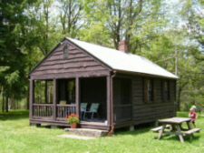
The structure on Page Pond is a 79' 6" International Derrick tower erected by the CCC in 1935. The tower was first operated in 1936 reporting 12 fires and 29 visitors. This tower ceased operation at the end of the 1988 season. The tower was officially closed in early 1989 when the Department of Environmental Conservation determined that towers were no longer effective and decided to phase them out of service. This tower was transferred to the existing landowner, the Girl Scouts Indian Hills Council in June 1992. As the tower and other improvements are now private property, the site is no longer open or available to the public. In 2007 the New York Chapter of the Forest Fire Lookout Association completed restoration work on both the tower and the cabin. |
|
|
|
The tower on Bova Mt. was one of two 30' steel tower erected by the Park in 1928. The other was erected on the hill behind the Administration Building at Red House. The only picture of the tower is seen on this 1940's ski brochure photo to the right. Anyone who may have an actual photo of tower when it stood on Mt. Irvine is encouraged to contact the NYS FFLA Director. |
|
Efforts were being made to establish a station here beginning in 1923. The structure on Hartzfelt was erected by the Conservation Commission in 1924. The funds for establishment, which included a 60' Aermotor LS40 tower and cabin, were provided by subscriptions from local landowners and towns in the vicinity of the station. In 1967, the Conservation Department realized the benefit of radio repeater stations to extend two-way communications and acquired the land where the tower stood for a repeater site serving Conservation Law Enforcement and others. Hartzfelt was staffed regularly until the advent of aerial detection caused this tower to be closed at the end of the 1970 season. The tower was dismantled and removed in 1973. |
|
Location: 5 miles northwest of Great Valley
The structure on McCarty was an 82' 6" International Derrick tower erected by the CCC Camp S-106, Salamanca in 1940. The tower was first staffed in 1941 reporting 4 fires and 980 visitors. Early references to this tower occasionally called it Irish Hill, which may have been the site initially proposed for this facility, but was decided against in lieu of McCarty Hill. Irish Hill is 6 miles northeast of McCarty Hill.
Since 1987, it also served as a repeater site for the Cattaraugus Co Sheriff's Department. The Department allowed the County to place an antenna on the tower and the related equipment in a small building at the base. A chain-link fence was also authorized for security reasons. In 1993 the Department entered into a Concurrent Use and Occupancy agreement that allowed the Sheriff's Department to erect a free standing tower on the site where the fire tower stood. The dismantling and removal of the fire tower and the erection of the new radio tower took place at the same time.
|
|
Location: In Allegany State Park
In 1928 the Conservation Department's Division of State Parks erected a standard 60' Aermotor LS40 tower on the east side of Allegany State Park on the highest point between the head waters of Rice Brook and South Carrollton Creek better know as Mt. Irvine. When jurisdiction over several State Parks towers was transferred to Forest Fire Control in 1931, Mt. Irvine was not one of them. The Park retained jurisdiction and staffed the tower only in times of high fire danger. By the end of 1928, the park had five fire towers in operation and felt that all five, working together, would provide excellent coverage of the park property. The three primary towers were Mt. Irvine, Mt. Tuscarora and Summit. Two other towers were also put in place. One was on the hill behind the Administration Building at Red House and the other on the western slope of Bova Mt. Three years after erecting the tower on Mr. Irvine, the Park moved it to Science Hill, a point southwest of the Bradford entrance near the Pennsylvania border, where it remained until 1978. It was then taken down by Park personnel and reassembled by an Ellicottville BOCES class near their school. Unfortunately, the only available picture is of the tower footers shown above. Anyone who may have an actual photo of tower when it stood on Mt. Irvine is encouraged to contact the NYS FFLA Director. |
|
In 1928 the Conservation Department's Division of State Parks erected a standard 60' Aermotor LS40 tower on Mt. Tuscarora on the southwest side of Quaker Run. When jurisdiction over several State Parks towers was transferred to Forest Fire Control in 1931, Mt. Tuscarora was not one of them. The Park retained jurisdiction and staffed the tower only in times of high fire danger. By the end of 1928, the park had five fire towers in operation and felt that all five, working together, would provide excellent coverage of the park property. The three primary towers were Mt. Irvine, Mt. Tuscarora and Summit. Two other steel towers were also put in place. One was on the hill behind the Administration Building at Red House and the other on the western slope of Bova Mt. Mt. Tuscarora still remains on-site today, but is in serious need of adoption and restoration. |
|
Pine Creek Fire Tower
Pine Creek tower was erected by the Civilian Conservation Corps - Indian Division through the auspices of the Bureau of Indian Affairs and the New York Indian Agency. The Indian Division Camps were separate and distinct from the conventional CCC Camps that worked throughout the State. The Indian Division Camps performed various types of conservation work on reservations all across the county. It's believed that this was the only camp of its type in New York State. The tower, erected about 1940, was a 54' Aermotor and is the only one of its manufacture and design in New York.
|
|
Location: Allegany State Park - On the hill behind the Administration Building at Red House Very little is known about this fire tower other than it was one of two 30' steel tower erected by the Park in 1928. The other was erected on the western slope of Bova Mt. above the ski area and is described above. Anyone who may have an actual photo of tower when it stood on Mt. Irvine is encouraged to contact the NYS FFLA Director. |
|
The tower on Science Hill was the 60' Aermotor LS40 tower that previously stood on Mt. Irvine. It was moved here by the Park in 1932 and, like the other Park towers, it was only staffed in times of high fire danger. It remained at this site until 1978 when it was then taken down by Park personnel and reassembled by an Ellicottville BOCES class near their school. Unfortunately, the only available picture is of the tower footers shown here. Anyone who may have an actual photo of tower when it stood on Mt. Irvine is encouraged to contact the NYS FFLA Director. |
|
The structure on South Mountain, referred to as Summit, is a 60' standard LS40 Aermotor tower erected by the Allegany State Park Commission in 1926. By the end of 1928, the park had five fire towers in operation and felt that all five, working together, would provide excellent coverage of the park property. The three primary towers were Mt. Irvine, Mt. Tuscarora and Summit. Two other towers were also put in place. One was on the hill behind the Administration Building at Red House and the other on the western slope of Bova Mt. In 1931 the Bureau of Forest Fire Control took over operation of this tower, as well as several other State Park's towers elsewhere in the State. With the advent of aerial detection, this tower was closed at the end of the 1970 season.
Restoration efforts were completed in 2006 and its re-opening was celebrated on a snowy October 14th of that year. However, the tower is now enclosed within a tall fence, and is off limits except on limited dates when the park allows entrance. Contact the park for details.
|
|
|
|
The structure on Berry Hill is a 59' 3" International Derrick tower provided to New York State by the US Forest Service and erected by the CCC in 1934. This tower was first staffed in 1935. It was built to look over many thousands of acres of State Forest lands that had been reforested and were considered to be susceptible to fire. This tower ceased operation at the end of the 1988 season. The tower was officially closed in early 1989 when the Department of Environmental Conservation determined that towers were no longer effective and decided to phase them out of service. This is one of only a few New York State towers that bears a manufacturers identification tag. It reads: "THE INTERNATIONAL DERRICK & EQUIPMENT Company (IDECO) Columbus, Ohio Los Angeles." This tower was placed on the National Historic Lookout Register in 1993. It still remains and the site is accessible but the tower is not. The stairway is gated to prevent access by the public. |
|
The structure at Chenango Lake was a 79' 6" International Derrick tower that was provided to New York State by the USFS and erected by the CCC. The footers was completed in 1934 and the tower completed in 1935. The tower was first operated in 1936 reporting 2 fires and 49 visitors. The tower was located about 4 miles northeast of Norwich in the Chenango County. The tower was staffed from 1936 through 1943 and again in 1946. In 1948 the tower was dismantled and moved to a site near Brookfield. |
|
The structure at Gilbert Lake State Park was an 80’ Aermotor LS40 tower erected by the CCC’s in 1934. Camp members staffed the tower during dry periods until its closure in 1941. From 1941 to 1948 there is no evidence that the tower was ever staffed. It was transferred to the Conservation Department in 1948 and moved to Leonard Hill in Schoharie County. |
|
|
|
The structure was an 82' 6" International Derrick tower and was begun by the CCC Camp S-103, DeRuyter in 1940 and completed in 1941. With the advent of aerial detection, this tower was closed at the end of the 1970 season. The tower was removed in November 1978. |
|
|
|
The structure at Brookfield was a 79' 6" International Derrick tower moved to this site by the Conservation Department in 1948. It was originally erected by the CCC on hill near Chenango Lake in 1934-5. With the advent of aerial detection, this tower was closed at the end of the 1971 season. This structure was sold and removed in 1983. |
|
The structure at Georgetown was 67' 6" International Derrick tower erected by the CCC Camp S-103, DeRuyter in 1940. It's actually located on Morrow Mt., which rises to 2,142 and is the highest point in Madison County. It's located near the center of the 1,290 acre Morrow Mountain State Forest and only two miles from the Hamlet of Georgetown, where it got its name. With the advent of aerial detection, this tower was closed at the end of the 1970 season and later removed. A New Hartford resident recently purchased the dismantled parts of the tower and hopes to re-erect the fire tower at his camp in Oppenheim, NY. 20 miles northeast of Johnstown. |
|
|
|
Location: 7 miles west of Watkins Glen.
In 1940 a tower was being secured for a site near Prattsburg. However, "the District Ranger wanted a tower on Sugar Hill hoping to see from one tower to the next and intersect fires in the Corning-Painted Post area" according to CCC Camp Monterey Superintendent Clarence Breckenridge. Consequently, the tower purchased for Prattsburg was diverted to this site. The structure is a 67' 6" International Derrick tower erected by CCC in 1941 on Sproul Hill, 2.5 miles NNW of the actual location of Sugar Hill. It was named, not for the hill on which it was erected, but for the reforestation area on which it is located. This, like many Southern Tier towers wasn't intended to be an extension of the close knit system of towers in the Adirondacks and Catskills but rather, most of these towers were located amidst large holdings on State Forest lands in order to protect those lands from fire. Additionally, the CCC built many miles of truck trails and fire breaks and hundreds of water holes for better access, to prevent fire spread and to aid in extinguishment when fires occurred. Many of these towers were only staffed on an as-needed basis by other Division of Lands and Forest personnel. The tower ceased operation at the end of the 1988 season. The tower was officially closed in early 1989 when the Department of Environmental Conservation determined that towers were no longer effective and decided to phase them out of service.
The tower still remains, is available to the public and is maintained by DEC Operations Unit in Region 8. |
|
|
|
Location: 4 miles west of Corning. The structure, on the Erwin Game Management Area, was an 82' 6" International Derrick tower erected by CCC Camp S-123, Beaver Dams beginning in 1940 and completed in 1941. This tower was first staffed in 1943 reporting 65 fires and 90 visitors. Erwin was staffed regularly until 1972 when the advent of aerial detection caused this tower to be closed and placed on the "Inactive" list. It was maintained for flood emergency communications until 1978. This structure was declared excess, no longer needed for either fire or flood emergencies, and was sold in 1979. |
|
A tower was purchased for this site in 1941 but was diverted to Sugar Hill by the local District Ranger. The structure ultimately erected near Prattsburg in 1950 by the Conservation Department was an 80' standard LS40 Aermotor tower. It was on private land and was per an easement with the owner, a Mr. Harold G. Shults. This, like many Southern Tier towers wasn't intended to be an extension of the close knit system of towers in the Adirondacks and Catskills but rather, most of these towers were located amidst large holdings on State Forest lands in order to protect those lands from fire. Additionally, the CCC built many miles of truck trails and fire breaks and hundreds of water holes for better access, to prevent fire spread and to aid in extinguishment when fires occurred. Many of these towers were only staffed on an as-needed basis by other Division of Lands and Forest personnel. The tower was staffed only sporadically during its 30 years and, with the advent of aerial detection, was closed at the end of the 1970 season. The tower fell into a bad state of disrepair due to vandalism and was systematically dismantled and piled at the site by the Department in October 1973. Portions of the tower still remain at the site. In May 1974 the Department executed a Release of Easement with a Mr. Girolmo, the new owner of the Prattsburg site, giving up all rights to the site.
|
|
|
|
The structure on Padlock Hill was a 67' 6" International Derrick tower erected by the CCC Camp S-125, Slaterville Springs in 1940. The tower was first staffed in 1941 reporting 52 fires and 705 visitors. This tower was closed in 1976 and sold at auction in 1977 to the landowner of the property on which it stood. In 1985, Padlock was donated to the State by the new owner. It was taken down and erected at the NYS Fairgrounds by Capt. Ed Pierce and the Region 7 Forest Rangers with the assistance from the local steel workers union and a local crane owner and operator. The tower is now a part of the permanent DEC exhibit at the New York State Fairgrounds.  |
|
|
 Location: 3 miles northeast of the Village of Alma.
  Many of these towers were only staffed on an as-needed basis by other Division of Lands and Forests personnel.
 Location: 3 1/2 miles north of West Almond.
 Location: 2 miles south of Binghamton.
 Location: 7 miles northwest of Deposit.
 Location: Allegany State Park - Above the ski area on the western slope of Bova Mt.
  Location: 4 miles south of Olean.


 Location: In Allegany State Park
  Location: On the Allegany Indian Reservation 3 miles southwest of the City of Salamanca.
  The stenciling on the steel brace shows the location to where the tower was originally shipped.
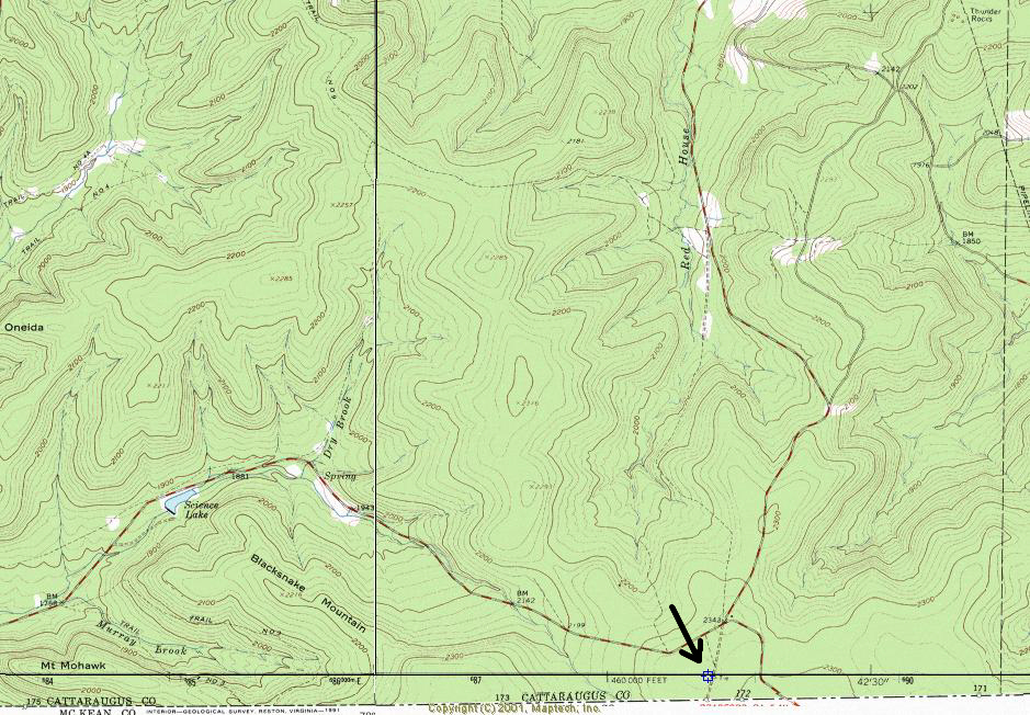
 Location:Southwest of the Bradford Entrance near the Pennsylvania border.
  Location: In the Allegany State Park, 2 miles south of Salamanca.
 The Fire Tower Restoration Committee, a part of the Allegany State Park Historical Society was formed in 1999. The
 Location: South side of Rt 319 at East Pharsalia.
 Location: 4 miles east of Norwich on the south side of State Rt. 23
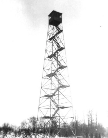 Location: Gilbert Lake State Park
 Location: 3 1/2 miles north of Truxton.
 Location: 5 miles southwest of the Hamlet of Brookfield.
 Location: 3 1/2 miles north of the Village of Georgetown.
 Sugar Hill Observer's Cabin - 2004 - A Warren Johnsen Photo">It appears on the
 Location: 2 miles northwest of the Village of Prattsburg.
 Location: 12 miles southeast of Ithaca.
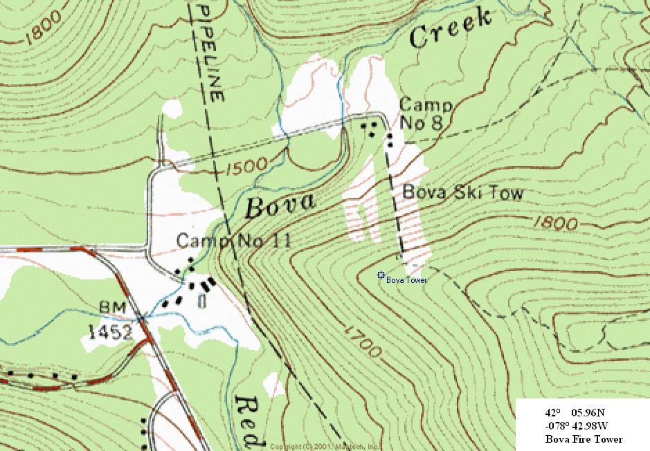