Visitor Count
Searchable list of NY Fire Towers
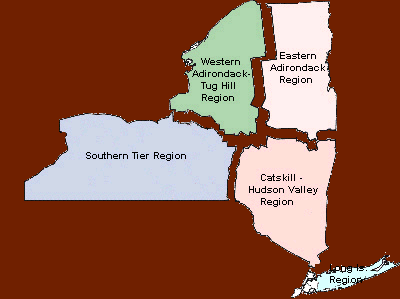
This list combines all of the regions and counties from the previous version which were in separate files.
 |

 |

|
 |
|
|
|
Alander Mt. Fire Tower Location: In the State of Massachusetts about one quarter of a mile east of the New York border.
At the top of Alander Mt., at an elevation of 2240', Conservation Department forest rangers supervised the erection a 60' Aermotor LS40 Aermotor tower. Such cooperation was the norm for the times as State Parks was another Division within the Conservation Department, being placed there in early 1927. Three miles of telephone line were constructed to connect the tower with the New York Telephone system. The tower was intended primarily for spotting fires on the Park. However, arrangements were made with the Park Commission so that fires on State land or private land outside the Park would be reported to the local fire wardens. In August 1930, the Commission received a notice from Mr. William A. Miles, of Salisbury, Conn. terminating the lease to the part of his property currently being used as the site for the fire tower. In response to Mr. Miles notice, the Park had the tower dismantled by the end of the year. The parts were placed in storage at High Valley Farm, the home of Commissioner Francis R. Masters, pending the possible relocation of the tower by the Conservation Department. It was not until 1932 that the Conservation Department agreed to accept the transfer of the tower from the Park Commission. The tower was then erected on private lands on Washburn Mt. in late 1932 and became operational in 1933. The tower remained on Washburn Mountain until 1964 when it was moved to Beebe Hill, where it remains today. |
|
Beebe Hill Fire Tower Location: 2 miles northwest of Austerlitz on the Beebe Hill State Forest.
The tower ceased operation at the end of the 1988 season and was officially closed in early 1989 when the Department of Environmental Conservation determined that fire towers were no longer effective and decided to phase them out of service. In 1997, Beebe Hill Fire Tower was added to the National Historic Lookout Register. Ten years after the closing of the facility, individuals came together to restore the fire tower and observer's cabin so that the public could safely continue to enjoy Beebe Hill for years to come. This group was made up of local residents, NYS-DEC Foresters, NYS-DEC Forest Rangers and members of the Forest Fire Lookout Association.
|
|
Washburn Mt. Fire Tower Location: On private lands, 1 mile southeast of Copake Falls near the New York / Massachusetts border.
The parts were placed in storage at High Valley Farm, the home of Commissioner Francis R. Masters, pending the possible relocation of the tower by the Conservation Department. It was not until 1932 that the Conservation Department agreed to accept the transfer of the tower from the Park Commission. The agreement stated that "the Commission would be glad to consider the transfer of the fire tower to the Conservation Department if the Conservation Department would agree to erect in within three months." In late 1932 the Conservation Department erected the 60" Aermotor tower on private lands on the summit of Washburn Mountain. The tower would remain on Washburn until 1964 when it was moved to Beebe Hill, where it remains today.
|
|
|
|
Bramley Mt. Fire Tower Location: 5 miles east of Delhi
|
|
Rock Rift Fire Tower Location: Tower Mt. about 2 miles northeast of the Hamlet of Rock Rift and north of the Cannonsville Reservoir.
This tower ceased operation at the end of the 1988 season and was officially closed in early 1989 when the Department determined that fire towers were no longer effective and decided to phase them out of service. This tower is currently owned by the Town of Tompkins, and there are plans for restoration underway. It remains on New York City DEP lands but is closed to the public. There is a public trail to the tower. |
|
Twadell Point Fire Tower Location: 1 1/2 mile north of the Hamlet of East Branch
By 1916 each observation station included a cabin for the observers comfort. Previously, most were provided only tents for shelter. These original cabins were usually constructed of logs cut on site. Most were small and less than ideal. In the early 20’s a standard design would be developed. This tower was closed at the end of the 1972 season and was sold to the landowner of the land on which it still stands. Though the tower still remains, it's on private land and is closed to the public.
|
|
Utsayantha Mt. Fire Tower Location: 2 miles southeast of the Village of Stamford
The first and only State structure on Utsayantha was a 59' 3" International Derrick tower erected by the CCC in 1934. The tower was closed at the end of the 1989 season, making it one of the last operating fire towers in New York State. Negotiations were completed in 2003 which allowed for the transfer of ownership of the tower to the Village of Stamford. A group was formed in 2003 to take on restoration of the tower as well as all other improvements on the mountaintop site. Restoration work began in 2004 and was completed in July of 2005 and a dedication held. FFLA worked on the restoration project. |
|
|
|
Beacon Mt. Fire Tower Location: 2 miles SE of the City of Beacon.
Historical data collected shows that a major community existed on top of North Beacon through the first half of the twentieth century. Access was gained to the mountaintop by means of an electric inclined railway that operated from 1901 to 1975 during which an estimated 3 million people road the railway to the 1540' summit, where a casino, hotel and numerous cottages existed.
The structure on South Beacon Mt. is a standard 60' Aermotor LS40 tower erected by the Conservation Department in 1931, which became operational in 1932. It is located about 2 miles southeast of the City of Beacon. The tower was established with funds from Dutchess Co and various private sources.
With the advent of aerial detection this tower was closed Beacon Mt. was added to the National Historic Lookout Register in December 2005. The tower still remains and a group has restored and maintains the tower. You can visit the group's website for more information on the project by clicking here. |
|
Clove Mt. Fire Tower Location: 7 miles south of the Village of Millbrook.
This tower ceased operation at the end of the 1988 season and was officially closed in early 1989 when the Department of Environmental Conservation determined that fire towers were no longer effective and decided to phase them out of service. Though the tower still remains, it's on private lands and is closed to the public. |
|
Ferncliff Forest Fire Tower Location: Ferncliff Forest in Rhinebeck, NY
|
|
Stissing Mt. Fire Tower Location: 2 mile west of Pine Plains.
This tower was first staffed in 1935 reporting 91 fire and 610 visitors. The tower is on the northern shoulder of the mountain at 1370' and not on the summit. The summit is 1403'. This tower ceased operation sometime between 1979 and 1982 but still remains. Marked trails take you to the tower. The trail to the right follows the Observer's jeep road and the telephone line. Poles can still be seen along this route. The tower has been restored by Friends of Stissing Landmarks and is open to the public. |
|
|
|
Hunter Mt. Fire Tower Location: 2 miles south of the Hamlet of Hunter.
The Conservation Commission replaced it with a 60' Aermotor LS40 tower in 1917. The tower lies 2 1/4 miles south of the Village of Hunter on New York State Forest Preserve lands. In 1950, the tower was moved northerly about 1000' to its current location on the true summit of the mountain, which was considered a more effective site. The tower ceased operation at the end of the 1988 season and was officially closed in early 1989 when the Department of Environmental Conservation determined that fire towers were no longer effective and decided to phase them out of service. Hunter Mt. Fire Tower has been restored and was reopened on August 7, 2000 as a part of the Catskill Fire Tower Restoration Project. It appears on both the National Historic Lookout Register and the National Register of Historic Places.

|
|
|
|
Bear Mt. Fire Tower Location:1 mile west-southwest of the Bear Mt. Bridge.

In 1928 the Palisades State Park Commission erected a 60' standard Aermotor LS40 tower on the summit of Bear Mt. in Bear Mt. State Park. The tower stood for only seven years and was then taken down to make way for the Perkins Memorial Tower erected in honor of George W. Perkins Sr., first president of the Palisades Interstate Park Commission, from 1900 to 1920. It was a gift of Perkins's widow and son in 1934, and for 19 years it was used as a weather station and fire lookout until it was closed in 1953. In 1990, the Perkins family donated $100,000 to defray the cost of producing new exhibits and also agreed to donate $650,000 over a period of years as an endowment for the maintenance of the tower. It was completely renovated and re-opened to the public. 
|
|
Black Rock Fire Tower Location: 2 miles South of Cornwall.
The tower was staffed during the high fire danger seasons by a Forest worker, but no formal map table was ever
constructed, nor was there an observer's cabin erected at the base. It is believed that by the time World War II
hit and drew off many men for selective service, that the use of the tower became little to none. In 1949, Stillman
died, and in his will, he endowed the entire Forest to Harvard University. Harvard took management of the Forest
and kept the fire tower open for hikers to use to take in the view. The DEC never had any direct involvement in this tower.
|
|
Fingerboard Mt. Fire Tower Location:3 miles southeast of Harriman.
The tower was operated by the Park until the early 1970's when it was closed and removed. |
|
Graham Fire Tower Location: 2 1/2 miles south of Otisville on the Shawangunk Ridge Trail.
There are 2 loops to the tower.
The tower ceased operation at the end of the 1988 season and was officially closed in early 1989 when the Department of Environmental Conservation determined that fire towers were no longer effective and decided to phase them out of service. Graham Tower appears on the National Historic Lookout Register.
Although the tower still remains, both it and the surrounding area are closed to the public. 
|
|
Pocatello Mt. Fire Tower Location: Southwest of Middletown on Sayers Hill.
Three years later in 1933, electricity was run to the tower to power a two-way radio that allowed the observer to talk with a Conservation Department airplane and a pickup truck equipped with a mobile radio as they patrolled the area. This first radio consisted of a 5-meter transmitter and receiver secured from the Radio Engineering Labs of Long Island City. The unit was assigned the identifier W10XBE and operated on a frequency of 62 megacycles.
|
|
Sterling Fire Tower Location: 2 miles south of the Hamlet of Greenwood Lake and between Sterling and Greenwood Lakes.
The tower ceased operation at the end of
the 1988 season and was officially closed in early 1989 when the
Department of Environmental Conservation determined that fire towers
were no longer effective and decided to phase them out of service.
It had been held as a "stand by" tower until 1999 when it was put back
into active service by the Office of Parks, Recreation and Historic
Preservation and now holds the distinction of being the only operating
fire tower in New York State. Pictured to the right is the Osborne Firefinder utilized for locating fires at Sterling. The Osborne is common in neighboring New Jersey but is the only one to ever be used for fire location purposes in New York. The firefinder is on loan to Sterling from the New Jersey Forest Fire Service and the Forest Fire Lookout Association. In 2019, the FFLA, the Friends of Sterling Forest, and the Park completed restoration work on the tower and Observer's cabin. The Friends group created a volunteer steward program that opens the fire tower on weekends from Memorial Day to Columbus Day.
 The Tower has a friends group located on facebook or their web page. |
|
|
|
Gilbert Lake Fire Tower Location: At Gilbert Lake State Park in the Town of New Lisbon, Otsego County
The CCC camp members staffed the tower during dry periods until its closure in 1941. From 1941 to 1948 there is no evidence that the tower was ever staffed. It was transferred to the Bureau of Forest Fire Control in 1948 and moved to Leonard Hill in Schoharie County. |
|
Hooker Hill Fire Tower Location: 7 miles south of Cooperstown.
This structure was sold in 1975 for $490. In November of 2001, the person who initially purchased it, transferred ownership to Marty Podskoch, author of three books on New York State Fire Towers, one volume on the Catskill Towers and two on the Adirondack Fire Towers. Since that time Marty has moved to the Connecticut. The tower parts are now in the hands of the Town of Speculator who have not at yet found a suitable place to erect it.
|
|
|
|
Nimham Mt. Fire Tower (aka Ninham) Location: 3 miles northwest of Carmel.
The structure on Nimham Mt. is an 82' 6" International Derrick tower erected by CCC Camp P-135, Peekskill in 1940. The tower was first staffed in 1941 reporting 73 fires and 266 visitors. Nimham Tower can be found about 3 miles northwest of Carmel on the Nimham Mt. State Forest. The tower ceased operation at the end of the 1988 season and was officially closed in early 1989 when the Department of Environmental Conservation determined that fire towers were no longer effective and decided to phase them out of service. This is one of only a few New York State towers that bears a manufacturers identification tag. It reads: "THE INTERNATIONAL DERRICK & EQUIPMENT Company (IDECO) Columbus, Ohio - Los Angeles." This tower appears on the National Historic Lookout Register. Local volunteers organized by the Town of Kent began restoring the tower in the mid-1990's. Their work was completed in the spring of 2005 and the official dedication held on July 24, 2005. |
|
|
|
Berlin Mt. Fire Tower Location: 4 miles east of the Hamlet of Berlin on State Route 22.
In 1921, following consultation with the US Forest Service, New York State formally expanded its forest fire detection and control responsibilities to the area east of the Hudson River, to include of part of Washington County and all of Rensselaer,Columbia and Dutchess Counties with the appointment of a District Forest Ranger Henry A. Teal. It's been reported that the States of Vermont, New York and Massachusetts shared in the funding of itsoperation for approximately three years. With the establishment of this new district, the cooperation of adjoining states was secured in detecting and reporting forest fires near the borders of New York. Along this boundary, Massachusetts authorities would use their observation towerson Berlin Mt., Osceola Mountain and Mt. Everett to report to the nearest fire wardens in New Your State any fires discovered on the New Yorkside of the line in Rensselaer, Columbia and Dutchess Counties. Similar agreements were made with Connecticut, New Jersey and Pennsylvania withregard to three other new districts established by the authorities in New York. In 1922, New York took the added steps of establishing forest fire observation stations at Number Seven Hill and Dickinson Hill, both in Rensselaer County. These additions seemed tonegate the need for the Massachusetts tower on Berlin Mountain to continue providing coverage for the county. Late in 1923, Massachusetts moved the tower to Brodie Mt to better serve the needs of thestate of Massachusetts.All that remains of this tower on Berlin Mt. are the footings. |
|
Dickinson Hill Fire Tower Location: 2 3/4 miles northeast of the Hamlet of Grafton
The structure on Dickinson Hill is a 60' Aermotor LS40 tower erected by the Conservation Commission in 1924. The tower was closed in the spring of 1974. The Beebe Hill tower, to the south, near the town of Austerlitz replaced this tower with respect to spotting forest fires. Until recently, the tower and the land on which it stands were under the control of the New York State Police. They use the site for a repeater tower to aid in radio communications. The Friends of Grafton Lakes State Park, a group formed several years ago, has been trying to convince the State Police to turn over the Dickinson Hill Fire Tower site to the State Park Commission so it can be safely restored and opened to park visitors. In early 2011 the transfer took place and the tower was restored. This tower appears on the National Historic Lookout Register and is open to the public. There is an interpretive trail that connects to a new visitor center tower as well.
A book entitled "I remember when: The Untold Story of Helen Ellett" written by Randy Kneer was officially released on June 11, 2011 at a book signing ceremony at the Grafton Lakes State Park. Helen and Randy were signing books all afternoon. |
|
Grafton Lakes Visitor Center Fire Tower Location: 2 3/4 miles northeast of the Hamlet of Grafton in Grafton Lakes State Park 
This tower, originally located in the Florida Panhandle at West Bay was relocated by Davana LLC for NYS Parks. Wanting to connect the next generation of young explorers to fire towers, the park had the tower installed in a playground next to the Grafton Lakes State Park Visitor Center in December of 2017. The structure around the first landing is meant as a safety barrier. 
|
|
Number Seven Fire Tower Location: 5 miles southeast of Averill Park.
With the advent of aerial detection, this tower was closed at the end of the 1970 season and has since been removed. |
|
|
|
Diamond Mt. Fire Tower Location:3 miles northeast of Sloatsburg The first steel tower here was constructed using the steel from the old Bear Mt. tower in 1935 by the Palisades State Park Commission. This tower was taken down in 1955, and the steel removed to the Merrit Bank yard for safe keeping. In 1966 the Park Commission purchased and erected an 80' Aermotor LS 40 tower which had louvered aluminum windows in the observation cab. It stood for twenty years until it too was removed in 1986. The Park's operation of it's fire towers ceased in the early 1980's because of manpower shortages and budget restrictions. The system of fire detection, enhanced by the towers at Fingerboard, Diamond, Jackie Jones and Sterling, came to a halt shortly afterwards, in 1989, when the Department of Environmental Conservation de-activated most of its fire observation stations. No photos of either of the Diamond Mt. towers have been located. Some steel pieces from these towers were used at Sterling Fire Tower to construct handrails and make other repairs when Sterling Forest State Park was created in 1998. |
|
Jackie Jones Fire Tower Location: 4 miles west of Stony Point on the south side of Rt. 210 at Lake Welch.
This tower ceased operation at the end of the 1988 season and was officially closed in early 1989 when the Department of Environmental Conservation determined that fire towers were no longer effective and decided to phase them out of service. In 1928, according to official documents, “The three new steel towers erected ... on Fingerboard Mountain, Tom Jones Mountain and Bear Mountain, with a wooden tower already on Jackie Jones Mountain, have given the Commission a complete system of fire control.” The above statement presents a bit of a dilemma, for other documentation indicates that a steel tower was erected on Jackie Jones Mt in 1928. It is more than likely that the tower originally intended for Tom Jones Mountain was diverted to Jackie Jones. This tower appears on the National Historic Lookout Register, still remains and is open to the public. It was restored by FFLA, Team Rubicon, and the Park in 2019. |
|
|
|
Leonard Hill Fire Tower Location: 1 mile south of Broome Center in southernmost Schoharie Co.
The tower ceased operation at the end of the 1988 season and was officially closed in early 1989 when the Department of Environmental Conservation determined that fire towers were no longer effective and decided to phase them out of service.
|
|
Petersburg Mt. Fire Tower Location: 3 3/4 miles southeast of Cobleskill.
With the advent of aerial detection, this tower was closed at the end of the 1971 season. The tower was transferred to Schoharie County for use as a radio tower sometime in the 1970's. The County removed the cab and added an additional 30’ to the tower in order to utilize it as an antenna support structure. The tower has been removed and replaced with an antenna support structure. The site is closed to the public. The tower was sold to Barry Knight who has relocated it to his property in West Hurley.
|
|
|
|
Chapin Hill Fire Tower Location: 8 miles southwest of Monticello.
With the advent of aerial detection, this tower was closed at the end of the 1970 season and has subsequently been removed. In 1941, a fire destroyed the Observer's cabin and burned the first 3 landings and stairs on the tower.
  |
|
Roosa Gap Fire Tower Location: 1 1/4 miles east of Summitville and US Rt. 209.
With the advent of aerial detection, this tower was closed at the end of the 1972 season later sold. The tower remains closed to the public. |
|
|
|
Balsam Lake Mt. Fire Tower Location: 5 miles northeast of the Hamlet of Hardenburg.
In 1887 the Balsam Lake Club built the first fire tower on Balsam Lake Mt. to protect its hunting and fishing lands. The tower was later destroyed by lightning in 1901. The Club built a second tower in 1905. This structure was the 35' wooden tower that was taken over by the Forest, Fish and Game Commission in 1909 as one of the first fire towers in New York State. in 1919, a 47 foot Aeromotor steel tower was erected, which still stands.The tower ceased operation at the end of the 1988 season and was officially closed in early 1989 when the Department of Environmental Conservation determined that fire towers were no longer effective and decided to phase them out of service. The tower appears on both the National Historic Lookout Register and the National Register of Historic Places, being placed on the latter in 2001. It can be found 1 3/4 miles south of the Hamlet of Belle Ayr on New York State Forest Preserve lands in the Balsam Lake Mt. Wild Forest. The tower has since been restored and reopened on June 3, 2000 as a part of the Catskill Fire Tower Project by the Friends of the Balsam Lake Mt. Fire Tower.
|
|
Upper Esopus Fire Tower Location: 1.5 miles north of Boiceville on Rt. 28.
This tower, an 80-foot Aeromotor MC-39, was first installed in Venice, Florida. In 2019, Davana LLC moved the tower and rebuilt it at the
Maurice D. Hinchey Catskills Visitor Center in Mt. Tremper, NY.
|
|
Belleayre Mt. Fire Tower Location: At Hightmount above the Belleayre Mt. Ski Center.
The tower, with its open platform and no cab for protection, was used until it was replaced with a 73' Aermotor LS40 tower in 1930. The station was relocated to afford better protection to a greater area than was given by the original structure. With the advent of aerial detection, this tower was closed at the end of the 1970 season. The tower remained on the "Inactive" list until it was destroyed by the Department of Environmental Conservation on March 3, 1985, the same year of the celebration of the 100th Anniversary of the Forest Preserve and the NYS Forest Ranger Force.
|
|
Gallis Hill Fire Tower Location: 3 miles northeast of Kingston.
The hill was reached via a short train ride from Kingston, which brought passengers close to the tower. This 1933 photo is through the courtesy of the George VanSickle Collection. Pictured are Mr. VanSickle's aunt and uncle. Thanks too goes to the Town of Hurley Historian, Deana Decker for helping to discover this very rare photo. In 1950 the tower was closed and moved 8 miles to the north to a new site on Overlook Mt. where it still remains today.
|
|
High Point Fire Tower Location: 3 miles east of Ellenville on the Shawangunk Range.
With the advent of aerial detection, this tower was closed at the end of the 1971 season and later removed.
|
|
Knight Tower (AKA Knightower)
Location: West Hurley, NY 
In 2002, Barry Knight moved the Petersburg tower from Esperance (where it had been stored many years before) to his property in West Hurley NY, where he painstakingly reassembled it to a height of 43 feet. It was finished in 2006. 
For more information, see this link. To visit this tower, contact Mr. Knight at 845-331-1214 |
|
Mohonk Fire Tower Location: 4 miles west of New Paltz and north of Rt. 299.
When the Smiley family, owners of Mohonk Lake and the Hotel, learned that the State was planning to replace the wooden tower with a steel structure they opposed it, offering instead to make a place in the new Smiley Memorial Tower for the observer. The tower, at its new location overlooking Mohonk Lake, was completed in 1923 and served as the fire observation station until May 1971 when this site was closed. The memorial tower still remains but is now open only to guests of the Mohonk preserve. It can be seen on a hill top when driving west from New Paltz on Route 299.
|
|
Overlook Mt. Fire Tower Location: 3 miles north of Woodstock and Rt. 212.
This tower ceased operation at the end of the 1988 season and was officially closed in early 1989 when the Department of Environmental Conservation determined that fire towers were no longer effective and decided to phase them out of service. The tower has been restored as a part of the Catskill Fire Tower Project and appears in the National Historic Lookout Register. |
|
Red Hill Fire Tower Location: 4.5 miles east of Claryville.
This tower was closed in 1990 and was one of the last operating fire towers in New York State. It appears on the National Historic Lookout Register and the National Register of Historic Places, being placed there in Sept 28, 2001. It can be found 4 1/2 miles east of Claryville on New York State Forest Preserve Lands in the Sundown Wild Forest. The tower has been restored and reopened on July 15, 2000 as a part of the Catskill Fire Tower Project.
|
|
Slide Mt. Fire Tower Location: 6 1/2 miles southwest of Phoenicia.
In 1934, a tower, purchased from State funds, was erected on Slide Mt. for observation purposes only. The 35' steel tower was never used for forest fire detection. Having fallen into a severely deteriorated condition, it was removed in 1968.
|
|
Tremper Mt. Fire Tower Location: 2 miles southeast of Phoenicia.
With the advent of aerial detection, this tower was closed at the end of the 1970 season. The tower has been restored and reopened on June 9, 2001 as a part of the Catskill Fire Tower Project.
It appears on the National Historic Lookout Register and the National Register of Historic Places, being placed on the latter in Sept 28, 2001. |
|
|
|
Cross River Fire Tower Location: 2 miles north of Pound Ridge on the Ward Pound Ridge Reservation.
With the advent of aerial detection, this tower was closed at the end of the 1970 season, sold in the mid 1970's and later removed.
Pictured below is the actual Morrow two-way radio used on Cross River in the 1950's.
|
|
Nelson Fire Tower Location: Salt Hill, 4 miles southwest of Peekskill and a mile north of the New Croton Reservoir.
 Evan Ravitz")
 Evan Ravitz")
With the advent of aerial detection, this tower was closed at the end of the 1971 season. Some time following that date the tower was cut down or pulled over by persons unknown and its remains are still on the summit.
|
|
|
 |
 |
|
|
|
Lyon Mt. Fire Tower Location: 7 miles west of Dannemora.
The tower ceased operation at the end of the 1988 season. The tower was officially closed in early 1989 when the Department of Environmental Conservation determined that towers were no longer effective and decided to phase them out of service.
|
|
Palmer Hill Fire Tower Location: 2 miles north of the Hamlet of Au Sable Forks
With the advent of aerial detection, this tower was closed in early 1971 and was placed on the "Inactive" list but was reactivated in 1979. It was active until closing at the end of the 1988 season and was officially closed in early 1989 when the Department of Environmental Conservation determined that towers were no longer effective and decided to phase them out of service. The tower still remains, is on private property and is closed to the public.
|
|
|
|
Mt. Adams Fire Tower Location: 4 mile northeast of the Hamlet of Tahawus.
With the advent of aerial detection, the tower was closed at the end of the 1971 season. The tower and cabin are on lands previously owned by the National Lead Co.
In 2003, the Open Space Institute (OSI) purchased about 10,000 acres of land from NL Industries. The area involved is commonly referred to as the Tahawus Tract. Within this acreage are the Mt. Adams Fire Tower, observer's cabin and related out buildings. As it was planned, a large portion of this property would be transferred to the State of New York and subsequently become part of the High Peaks Wilderness Area, requiring that the tower and related structures be removed.
Considerable pressure was brought, and the
involved parties, OSI and the DEC, arrived at an arrangement where the
surrounding lands would be transferred to the State with the exception
of the tower and cabin sites. These would be retained by OSI so that
historic preservation and restoration work could be commenced.
Restoration work was begun on the tower by the DEC through AmeriCorp volunteers of the Student Conservation Association. A friends group, ADK High Peaks Foundation, completed the restoration work, including a new roof. In early April 2006 the Adirondack Park Agency gave final approval to the plan for the Tahawus Tract. In view of this latest development, Mt. Adams should have a bright future.
The cabin on Adams, built in 1922, is the
oldest surviving in the state and one of the first of a standard design
established by the Conservation Commission that same year. OSI restored the cabin in September 2007. Mt. Adams now appears on the National Historic Lookout Register.
|
|
Belfry Mt. Fire Tower Location: Near Mineville, 8 miles southwest of Westport.
The tower ceased operation at the end of the 1988 season. The tower was officially closed in early 1989 when the Department of Environmental Conservation determined that towers were no longer effective and decided to phase them out of service. The tower is on private lands and supports multiple radio antennas.
|
|
Boreas Mt. Fire Tower Location: 8 miles northwest of the Hamlet of North Hudson.
With the advent of aerial detection, this tower was closed at the end of the 1971 season and later removed.

|
|
Goodnow Mt. Fire Tower Location: South of Rt. 28N 2 miles west of Newcomb.
The structure on Goodnow Mt is a 60' Aermotor LS40 tower erected by the Conservation Commission in the early spring of 1922. The tower was closed at the end of the 1979 season. It was later transferred to the landowner, SUNY College of Forestry, Huntington Forest. The tower and cabin have been completely restored by the landowner and the tower is open to the public. Goodnow Mt. now appears on the National Historic Lookout Register.
|
|
Hurricane Mt. Fire Tower Location: North of Rt. 9N, 5 miles west of Elizabethtown.
The tower was closed about 1979. The tower was slated for removal in late 2001 or in 2002 as it was deemed a "non-conforming structure" in the Hurricane Mt. Primitive Area. However, the area has been reclassified and the fire tower has been restored by The Friends of Hurricane Mountain Fire Tower group. Hurricane Mt. appears on the National Historic Lookout Register.
After a five year battle, on April 15, 2010 the Adirondack Park Agency has yielded to public pressure to allow both Hurricane and St. Regis Mountain Fire Towers to remain where they stand and amend the State Land Master Plan to recognize this decision. In addition, the Adirondack Council, who campaigned long and hard for their removal has indicated that it will not challenge the decision in the courts. To read of the decision click here.
|
|
Makomis Mt. Fire Tower Location: 1 mile east of Underwood and near the intersection of I-87 and State Rt. 73.
A self-supporting staircase was developed by Aermotor, for installation in the towers purchased in 1916. This staircase amounted to a tower within a tower and was anchored to the original tower. These were purchased to replace the wooden stairs currently in use and were installed in this tower in 1933. With the advent of aerial detection, this tower was closed at the end of the 1970 season and later removed. In 2019, the fire tower was purchased by Mike Vilegi who restored it. Article

|
|
|
|
Pharaoh Mt. Fire Tower Location: 5 miles east of Schroon Lake in the Pharaoh Lake Wilderness Area.
There is no evidence that a tower was ever built on Pharaoh until 1918, when the Conservation Commission erected a 35' Aermotor LS40 tower. The tower was closed in 1987. The structure was later removed because it was felled by vandals. Click here to view a news article |
|
Poke-O-Moonshine Mt. Fire Tower Location: 7 miles south of Keeseville and west of I-87.
This made it possible for an inexperienced observer to locate fires more accurately than by using ordinary topographic maps. The Osborne was first tried out at Poke-O-Moonshine Mt. during that same year and a map was made. It was considered so successful that in the years to follow the Osborne was carried up to each mountain station and a map made. This project took several years to complete.
The inner portion was a topographic map with the tower location in the center. A sighting device called an "alidade" pivoted on a pin in the center of the map. Along the outer edge of the topographic map portion are azimuths that could be easily read by the observer once the alidade was sited on a possible fire. The outermost edge of the map is the panorama or a sketch of what the observer could actually see from the mountain station.
While these were very helpful to the observer in locating a possible fire, there was a downside to the concept.
Vast areas of the Adirondacks and Catskills didn't appear on any stations maps requiring they use the previous methods of location. Triangulation, as a method of locating fires, didn't come in to its own until the 1940's. Years later, use of a 30 inch diameter map was instituted that effectively did away with this problem but created another. The panoramic sketches that were so helpful to the new observer had to go. This tower ceased operation at the end of the 1988 season. The tower was officially closed in early 1989 when the Department of Environmental Conservation determined that towers were no longer effective and decided to phase them out of service. In 1994, a group known as the Friends of Poke-O-Moonshine was formed to save and restore the tower. Poke-O-Moonshine appears on both the National Historic Lookout Register and the National Register of Historic Places, being placed on the latter on Sept 28, 2001.

|
|
Vanderwhacker Mt. Fire Tower Location: 4 miles west of Rt. 28 at Aiden Lair.
This tower ceased operation at the end of the 1988 season. The tower was officially closed in early 1989 when the Department of Environmental Conservation determined that towers were no longer effective and decided to phase them out of service.
|
|
Whiteface Mt. Fire Tower Location: East of Lake Placid.
When this observation station was established in July 1909, no tower was immediately erected, as an unobstructed view was available due to the lack of tree cover on the mountaintop. All that was initially provided was a pole frame structure with a canvas tent stretched over it so that the observer could get in out of the weather. The shelter was later improved to a stone hut. Finally, in 1919, a steel 22' Aermotor tower was erected on the mountaintop. (Click here to view news article) In 1930, along with the memorial highway, a 46 foot memorial tower with a 60" revolving light was proposed to honor the Veterans of the World War. (Click here to view news article) As time passed the proposal grew to major proportions. It was finally proposed through the legislative process that the tower be of stone and be 70 feet tall. The authorizing legislation was ultimately vetoed by Governor Legman, putting the memorial tower idea to rest. (Click here to view news article) With the completion of the memorial highway, there followed a rather lengthy dispute over which agency, the Conservation Department or the State highway Department, would have control over the fire tower on Whiteface. Governor Lehman finally stepped in the ruled in favor of the Conservation Department in June of 1935. Following completion of the highway and the determination that there would be no memorial tower on Whiteface, the State completed the improvements on the mountaintop which included the Summit House and the tunnel and elevator in 1937. With the advent of aerial detection, this tower was closed at the end of the 1970 season. A year and a half later, on May 23, 1972, Whiteface was the first of many towers to be removed from Adirondack mountaintops. Some because they were deemed no longer necessary and others because they were considered "non-conforming structures" pursuant to the new Adirondack State Land Master Plan produced by the newly created Adirondack Park Agency. On that date, Forest Rangers and Operations personnel dismantled the tower marking the pieces for possible future use. Rangers and Operations personnel then loaded the shorter pieces into the elevator but the longer steel struts and leg sections were carried down the rocky path to waiting trucks at the end of the Memorial Highway. The tower's historical sign remained on the mountaintop for another year, when it was removed and eventually donated along with the tower to the Museum where both remain on display to this day.
 |
|
New Location of Whiteface Mt. Fire Tower Location: Blue Mountain Lake, at Adirondack Experience, The Museum on Blue Mountain Lake. Status:Relocated, rebuilt and open to the public. See previous entry for the history of this tower.  |
|
|
|
Ampersand Mt. Fire Tower Location: South of State Rt. 3 between Saranac Lake and Tupper Lake.
|
|
Azure Mt. Fire Tower Location: 6 miles south of Santa Clara.
This tower was closed at the end of the 1979 season and now appears on both the National Historic Lookout Register and the National Register of Historic Places being placed on the latter September 28, 2001. An initial meeting of the of Azure Mt. Friends took place in November of 2001 to organize restoration of the facility. The tower has been completely restored and was officially "opened" on Sept. 27, 2003. A new map was also created and installed in the cab using the original metal supports.
|
|
Debar Mt. Fire Tower Location: 4 miles northeast of Meacham Lake.
|
|
Loon Lake Mt. Fire Tower Location: 4 miles west of Loon Lake and the Hamlet of the same name.
With the advent of aerial detection, this tower was closed at the end of the 1971 season. The tower is not open to the public. In 2010, the trail to the summit was opend by means of a Conservation Easement between the DEC and the landowner.
|
|
Meenahga Mt. Fire Tower Location: 7 miles north of Bloomingdale on the northwest side of Rainbow Lake.
The structure on Meenahga is a 73' Aermotor LS40 tower erected by Conservation Department Forest Ranger Albert Tebeau in 1927 for the Adirondack-Florida School. (Click here to view news article) Ranger Tebeau erected most of the fire observation stations in the northern Adirondacks. While it was primarily for the use of the School, the tower would be used as a fire observation station through an agreement between the School and the Department. The tower still remains on private land and is closed to the public.
|
|
Mt. Morris Fire Tower Location: South of the Village of Tupper Lake.
|
|
St. Regis Mt. Fire Tower Location: 4 miles south west of Paul Smiths.
In 1918 the State Conservation Commission
purchased a new device known as the Osborne Fire Finder. With this,
they developed new circular maps for each tower with a panoramic sketch
of the view from the tower around the outside perimeter. In the 1930's the Conservation Department experimented with two way radios to improve communications between its fire towers and forest rangers. The first radio ever used on St. Regis Mt. is pictured here. This should not be confused with a radio that is similar in make to the one first used, for this is the actual radio once used on St. Regis Mountain. St. Regis Mt. Fire Tower appears on both the National Historic Lookout Register and the National Register of History Places being placed on the latter in 2005. This development is viewed positively by the supporters of preserving the site. A "friends" group has been formed and is headed up by David Petrelli who can be contacted by clicking here or you can read about their efforts to save and restore the tower by clicking here. St. Regis is one of the mountains included in the Fire Tower Challenge sponsored by the Glens Falls-Saratoga Chapter of the Adirondack Mountain Club (ADK). "To complete the Challenge and receive the official full-color patch, hikers must climb and document, by date, ascents of at least 23 fire tower summits: 18 of 23 Adirondack Park summits and all 5 Catskill Park summits."
|
|
|
|
Kane Mt. Fire Tower Location: 3 Miles north of the Village of Caroga Lake.
|
|
|
|
Blue Mt. Fire Tower Location: Northeast of the Hamlet of Blue Mt. Lake.
Blue was operational for 80 years and one of the longest operating towers in the State, second only to St. Regis which operated continuously for 81. During all those years there were four different cabins provided for the observer. The first was a log structure and the other three were of frame construction.
In the 1950's, the "Cold War" raged and the threat of nuclear annihilation was a serious concern. The USAF had developed a long range radar system to protect against enemy bombers. In addition, they developed and deployed what where known as gap-filler radar stations. Having a range of around sixty-five miles, these radar installations were placed in areas where it was thought enemy aircraft could fly low to avoid detection by the longer-range radars of the permanent and mobile radar networks. One such gap-filler radio station was installed on the summit of Blue Mountain. The station became operational in January of 1959 and was decommissioned in December 1967.  In 1992, the Blue Mt tower and cabin were seriously vandalized by unknown individuals. This occurred about the same time Pharaoh was toppled and some believe it may have been done by the same people. (Click here to view a news article) Blue Mt. has been adopted and restored by local volunteers. FFLA, Team Rubicon, and NYS DEC did significant work on the tower in 2019. |
|
Buck Mt. Fire Tower
Location: 484 South Sabattis Circle Road off NYS Route 30, eight miles north of the Long Lake Town center.
The Buck Mountain Fire Tower was constructed in 1933 on the land formerly owned by Whitney Park now owned by Cedar Heights Timber, LLC.
It is a 60 foot steel Aeromotor LS-40 model tower. The summit elevation is 2400 feet. The original construction materials for the tower were hauled to the top of Buck Mountain
by a dog sled team with lead dog St. Luniare led by Jack Bursey. Both Bursey and St. Luniare accompanied Admiral Richard Byrd on his historic trip to the South Pole in 1929.
In 2022, rehabilitation of the 60 foot fire tower began, under the direction of fire tower consultant Mike Vilegi from Excelsior Fire Tower Group.
The fire tower rehabilitation included installation of a new sheet metal roof, treads, galvanized steps and fencing.
The 1.2 mile (one way) trail with 500 feet in elevation gain was built through collaborative community partnerships between the NYS Chapter of the Forest Fire Lookout Association,
Hamilton County Soil and Water Department, Hamilton County Highway Department, the Hamilton County Board of Supervisors, the Adirondack Mountain Club, and the Town of Long Lake.
The trail was made possible through the generosity of Cedar Heights Timber LLC, which granted an easement across a scenic portion of its land to this historic fire tower
overlooking the William C. Whitney Wilderness.
The tower reopened to the public on September 2, 2023.
|
|
Cathead Mt. Fire Tower Location: 7 miles northwest of Northville.
In 1916, the Conservation Commission replaced the wooden tower with a 50' Aermotor LL25 tower. It was of a lighter weight than their 1917 design and had no stairs but only a ladder up the exterior for the purpose of ingress and egress. Wooden steps were added within the structure to ease access for both the Observer and the general public in 1918 or 1919. (Click here to view a news article)
Access to Cathead is closed to the public because of a dispute between the Department of Environmental Conservation and a private landowner. In order to comply with APA policy, which prohibits the placement of any additional towers within the Park, a tower frame was constructed over and attached to the current tower to provide space for radio repeaters and their antennas for various governmental agencies.
|
|
Dun Brook Mt. Fire Tower Location: 6 miles northeast of Blue Mt. Lake. The only structure on Dunn Brook Mt was a wooden tower constructed by the Conservation Commission in May 1911. This tower was closed in 1920. There are no photos or other information to be had on this site.
|
|
Hamilton Mt. Fire Tower Location: 5 miles southeast of Lake Pleasant.
Wooden steps were added within the structure to ease access for both the Observer and the general public in 1918 or 1919. These were later replaced with a steel staircase with wood treads as shown in the adjoining picture.
With the advent of aerial detection, this tower was closed at the end of the 1971 season. This structure was removed about 1977 because it was deemed excess to the fire detection needs of the Bureau of Forest Fire Control and additionally was classified as a "non-conforming structure" in the newly established Silver Lake Wilderness Area.
|
|
Kempshall Mt. Fire Tower Location: 5 miles northeast of the Village of Long Lake.
With the advent of aerial detection, this tower was closed at the end of the 1971 season. This structure was removed because it was deemed excess to the fire detection needs of the Bureau of Forest Fire Control and additionally was classified as a "non-conforming structure" in the newly established High Peaks Wilderness Area. This tower has been removed. Portions of this tower and the West Mt tower were used to erect the tower that now stands at the Essex County Historical Museum in Elizabethtown NY.

|
|
Owls Head Mt. Fire Tower Location: 4 miles southwest of the Village of Long Lake.
The tower is restored and is open to the public. It was added to the National Historic Lookout Register in 2006.
|
|
|
|
Pillsbury Mt. Fire Tower Location: 9 miles northwest of Speculator.
This tower was closed about 1985. It still remains and can be accessed by the public. Pillsbury Mt. now appears on the National Historic Lookout Register.
The tower was recently restored by the NYS Chapter of the FFLA.
|
|
Salmon Lake Mt. Fire Tower Location: 10 miles north of the Village of Raquette Lake.
The tower had no stairs but only a ladder up the exterior of the structure for the purposes of ingress and egress. The structure still remains, is in poor condition and is not open to the public. Hours of intensive searching of numerous Internet sites relating to fire towers and forest fire prevention on both the state and national levels, as well as the National Historic Lookout Register and the National Register of Historic Places, revealed that the structure on Salmon Lake Mt. is quite likely one of only a few remaining Aermotor LX24 design towers still standing in the United States. |
|
Snowy Mt. Fire Tower Location: 7 miles southwest of Indian Lake and west of State Rt. 30.
With the advent of aerial detection, this tower was closed at the end of the 1971 season. The tower appears on the National Register of Historic Places, being placed there Sept 23, 2001. The DEC and local volunteers restored the tower in 2001. FFLA has an agreement with NYS DEC to maintain the tower. Below, to the left, is a great vintage
photo of Observer Alvin Mattison from the collection of Dan Locke. To
the right is a postcard generated from the Locke photo. Postcards can
be a great research tool as, in the instance of fire towers, most are
made from actual photographs, even in the early 1900s.
|
|
T Lake Mt. Fire Tower Location: 3 miles northwest of Piseco Lake.
With the advent of aerial detection, this tower was closed at the end of the 1970 season. This structure was removed because it was deemed excess to the fire detection needs of the Bureau of Forest Fire Control and additionally was classified as a "non-conforming use" in the newly established West Canada Lakes Wilderness Area. In 1977 the U. S. Army engineers were allowed to test shaped explosive charges on the fire tower which brought the tower crashing down. Within a few weeks the remains of the tower were flown out by helicopter.  Residents of Piseco Lake made several unsuccessful pleas to then DEC Commissioner Peter A. A. Berle to obtain the tower for air traffic control purposes at the Piseco Airport.
|
|
Tomany Mt. Fire Tower Location: 4 miles northwest of Arietta and west of State Rt. 30.
A self-supporting staircase was developed by Aermotor, for installation in the towers purchased in 1916. This staircase amounted to a tower within a tower and was anchored to the original tower. These were purchased to replace the wooden stairs currently in use and were installed in this tower in 1929, the same year the three photos appearing above were taken.
With the advent of aerial detection, this tower was closed at the end of the 1970 season. This tower was later dismantled and the pieces scattered near the summit.
|
|
Wakely Mt. Fire Tower Location: 12 miles southwest of Indian Lake.
Wooden steps were added within the structure to ease access for both the Observer and the general public in 1918 or 1919. (Click here to view a news article) A self-supporting staircase was developed by Aermotor, for installation in the towers purchased in 1916. This staircase amounted to a tower within a tower and was anchored to the original tower. These were purchased to replace the wooden stairs currently in use and were installed in this tower.
FFLA has an agreement with NYS DEC to maintain this tower. |
|
West Mt. Fire Tower Location: 4 miles north of Raquette Lake in the Pigeon Lake Wilderness area.
In 1920 it was replaced with a 47' Aermotor LS40 tower by the Conservation Commission. To move the steel from the railroad station in the Hamlet of Raquette Lake to the tower site the Commission hired a local woodsman and guide Billy Payne and his ox Tommy for the job. 
With the advent of aerial detection, this
tower was closed at the end of the 1970 season. This structure was
removed because it was deemed excess to the fire detection needs of the
Bureau of Forest Fire Control and additionally was classified as a
"non-conforming use" in the newly established Pigeon Lake Wilderness
Area.
Portions of this tower and the Kempshall Mt.
tower were used to erect the tower that now stands at the Essex County
Historical Museum in Elizabethtown NY.
|
|
|
|
Cornell Hill Fire Tower Location: 2 1/2 miles east of Malta on US Route 9.
The structure on Cornell Hill is a 60' Aermotor LS40 tower erected by the Conservation Commission in 1923 and was operational in 1924. Of historical importance, the observer pictured, Noah LaCasse served as the observer on Cornell Hill from 1925 to 1934. In 1901 Mr. LaCasse was a guide in the party of then Vice President Theodore Roosevelt at the time he was hiking to Mt. Marcy when President McKinley was assassinated in Buffalo N. Y. With the advent of aerial detection, this tower was closed at the end of the 1970 season. The tower now appears on the National Historic Lookout Register. In the summer of 2008, the Luther Forest Corporation dismantled and moved the tower to a new site on the former Boy Scout Camp Saratoga which is now a part of the Wilton Wildlife Refuge.
|
|
Hadley Mt. Fire Tower Location: 8 miles northwest of the Village of Lake Luzerne.
A self-supporting staircase was developed by Aermotor, for installation in the towers purchased in 1916. This staircase amounted to a tower within a tower and was anchored to the original tower. These were purchased to replace the wooden stairs currently in use and were installed in this tower in 1929. The tower was blown over during a hurricane in October 1919 but was quickly re-erected and back in operation for the 1920 season. During that same storm, Gore Mt. Tower was also blown down. This tower was closed August 24, 1990, being one of the last active fire towers in New York State. The tower has been restored by the Hadley Fire Tower Committee in the late 1990's and now appears on the National Historic Lookout Register and the National Register of Historic Places, being placed there in Sept 23, 2001.
|
|
Ohmer Mt. Fire Tower Location: 10 miles northeast of the Village of Northville. The only structure on Ohmer was a wooden tower erected by the Conservation Commission in October 1911. The tower was closed in 1916, as satisfactory arrangements could not be made for its continuance. A steel tower was constructed on Hadley Mt. in 1917 to replace Ohmer.
|
|
Spruce Mt. Fire Tower Location: 2 miles northwest of South Corinth.
The tower ceased operation at the end of the 1988 season. The tower was officially closed in early 1989 when the Department of Environmental Conservation determined that towers were no longer effective and decided to phase them out of service.
|
|
|
|
Crane Mt. Fire Tower Location: 6 miles south of Wevertown.

|
|
Gore Mt. Fire Tower Location: 4 miles west of the Village of North Creek.
This tower ceased operation at the end of the 1988 season. The tower was officially closed in early 1989 when the Department of Environmental Conservation determined that towers were no longer effective and decided to phase them out of service. The tower still remains and is used as a communications relay tower with numerous dish antennas attached to it.
|
|
Prospect Mt. Fire Tower Location: West of the Village of Lake George.
With the advent of aerial detection, this tower was closed at the end of the 1970 season and later removed.
|
|
Swede Mt. Fire Tower Location: South of State Rt. 8, 5 miles west of Hague.
With the advent of aerial detection, this tower was closed at the end of the 1970 season. The tower and cabin are owned by Warren county. In 2021, Warren County finished building a new trail to the tower, which passes thru private property via an easement. They also refurbished the tower. The terms of the easement specify that the trail to the tower is open from December 16th thru September 10th. As of 2022, the Observer's cabin has partially collapsed. |
|
|
|
Black Mt. Fire Tower Location: East side of Lake George. The first structure on Black was a wooden tower constructed by the Conservation Commission in May 1911. In 1918, the Conservation Commission replaced the wooden tower with a 35' Aermotor LS40 tower. The tower ceased operation at the end of the 1988 season. The tower was officially closed in early 1989 when the Department of Environmental Conservation determined that towers were no longer effective and decided to phase them out of service. Black Mt. is currently being used as a radio repeater and relay site for various police agencies and the tower itself is closed to the public. However, excellent views of Lake George and the surrounding area can been seen from the area adjacent to the tower site. Of a truly historic nature, just north of the tower, is an etching or scratching on the rock that reads: "R. Rogers 1763". This was apparently done by Robert Rogers of the colonial era "Robert's Rangers". The marking has been deemed authentic by the New York State Education Department. The pictures below show the evolution of the Black Mt. Fire Tower from the days when it was simply a fire to tower, to when it served as an approach beacon for Glens Falls Airport to the present were it's used solely as a communications site and looks very similar to the monstrosity on Cathead Mt. 


|
|
Colfax Mt. Fire Tower Location: 5 miles east of Greenwich and 4 miles north of Cambridge.
With the advent of aerial detection, this tower was closed at the end of the 1970 season. The tower still remains but is closed to the public.
|
|
|
- Adirondack Fire Towers & Tug Hill Fire Towers
 |
 last edited 03/23/2017 @ 2310 |
|
|
|
Bald (Rondaxe) Mt. Fire Tower
Location: North of State Rt. 28, 3 1/2 miles northeast of Old Forge.
This tower was closed in 1990 and was reputedly the last operating fire tower in the ADKs. It now appears on the National Historic Lookout Register and the National Register of Historic Places, being added to the latter on September 23, 2001.
The group, The Friends of Bald Mountain, was formed about 2002 and has since restored the tower to its original condition. The "Re-opening Dedication" was June 18, 2005. For detailed information about their work, visit their site by clicking here. The Friends of Bald Mountain restored the tower. They provide trail maintenance, signage, and an educational component. |
|
Beaver Lake Mt. Fire Tower
Location: 4 miles northeast of the Hamlet of Number Four. When this observation station was established in July 1910, no tower was immediately erected due to the lack of tree cover on the mountaintop.
This structure was removed in 1977 because it was deemed excess to the fire detection needs of the Bureau of Forest Fire Control and additionally was classified as a "non-conforming structure" in the newly established Pepperbox Wilderness Area. |
|
Dairy Hill Fire Tower
Location: 5 miles east of the Village of Newport.
|
|
Ft. Noble Mt. Fire Tower
Location: North of State Rt. 8 at Nobleboro on the Herkimer - Hamilton County line.
It was of a lighter weight than their 1917 design and had no stairs but only a ladder up the exterior for the purpose of ingress and egress. Wooden steps were added within the structure to ease access for both the Observer and the general public in 1918 or 1919. (Click here) for a news article describing these early design of towers. The 1950's vintage picture to the right shows a horizontal pole with wires attached. This was the antenna for the AM two-way radio system. The tower was closed in 1978. This structure was later removed because it was deemed excess to the fire detection needs of the Bureau of Forest Fire Control and additionally was classified as a "non-conforming use" in the Ft. Noble Primitive Area. Once the tower was removed, it paved the way for changing the land classification to Wilderness. |
|
Moose River Mt. Fire Tower
Location: 2 miles west of Thendara in the Ha-de-ron-dah Wilderness Area.
This structure was removed in 1977 because it was deemed excess to the fire detection needs of the Bureau of Forest Fire Control and additionally was classified as a "non-conforming use" in the newly established Ha-de-ron-dah Wilderness Area. |
|
Mt. Electra Fire Tower
Location: 4 miles north of the easterly end of the Stillwater Reservoir.
The structure on Mt. Electra, previously known as Rock Lake Mt, was a 60' Aermotor LS40 tower erected by the Webb Estate about 1920. The actual date of construction cannot be verified. This served as a "secondary tower" and it is suspected that the landowner provided an observer during periods of dry weather. Further research by Marty Podskoch revealed that the State and Webb family had an understanding where by the State would share in the cost of paying the observer but the Webb family would do the hiring. In one instance in 1942, Department records show that the observer, Francis Boone's salary was paid at least partially by the State of New York. Francis Boone was the sister of Forester Charlie Boone who would become the Supt. of the Bureau of Forest Fire Control in the early 1970's. The property and the tower became a part of the New York State Forest Preserve
|
|
Stillwater Mt. Fire Tower
Location: West of the Stillwater Reservoir.
The tower ceased operation at the end of the 1988 season. The tower was officially closed in early 1989 when the Department of Environmental Conservation determined that towers were no longer effective and decided to phase them out of service. The tower remains on lands of the Lyme Timber Company and through an agreement with NYS DEC is open to the public except for the 2nd Tuesday in October through December 20th, when it is closed for hunting season. The Friends Of Stillwater Fire Tower reorganized in 2015 and fully restored the tower by July of 2016 when a grand reopening was held. The Observer's cabin still stands about .1 miles south and across the road from the trailhead. It is used by seasonal DEC employees. FFLA holds the VSA for this tower with the assistance of the Friends group. Volunteer stewards staff the tower on weekends. |
|
Woodhull Mt. Fire Tower
Location: 6 miles south of Old Forge.
The tower was closed at the end of the 1970 season when the DEC instituted aerial based wildfire detection. This tower still remains and is accessible to the public with the exception of the tower cab. |
|
|
|
Bald Mt. Fire Tower
Location: 9 miles northeast of Indian River.
With the advent of aerial detection this tower was closed at the end of the 1970 season. Ownership of the structure was transferred to the landowner. Due to liability concerns, the owner, Diamond International, had the leg bolts removed and the tower pulled over. Its twisted remains were left at the site.
In 1989 the new owner of the 18,000 acre tract, Henry Lassiter, entered into an agreement with the DEC, formally known as a "conservation easement", whereby the State purchased the development and recreation rights leaving the land itself and the timber in private ownership. This allows the public use of the land while the owner continues to manage and harvest the timber. Each easement has its own stipulations. Individuals wishing to visit the site may do so, though, without the tower, there is no view.
|
|
Gomer Hill Fire Tower
Location: 4 miles west of the Hamlet of Turin.
This tower ceased operation at the end of the 1988 season. It was officially closed in early 1989 when the Department of Environmental Conservation determined that towers were no longer effective and decided to phase them out of service.
|
|
Moose River Fire Tower
Location: Adjacent to the Moose River Rd. half way between the Hamlets of Moose River and Porters Corners. The first and only structure at this site was a wooden tower erected by the Conservation Commission in 1912 adjacent to the Moose River Rd in the Town of Lyonsdale, Lewis County. When a steel tower was purchased in 1919, it was erected at a new site, eleven miles to the northeast of this location and three miles west of Thendara in the Town of Webb, Herkimer County. With the establishment of the new tower on what would be known as Moose River Mt., this site was abandoned. |
|
New Boston Fire Tower
Location:North of State Rt. 177 at the Hamlet of New Boston.
With the advent of aerial detection, this tower was closed at the end of the 1970 season. The tower was dismantled and removed by DEC personnel in 1982 to the facilities in Harrisville. The tower was then loaned to the Thompson Park Zoo, in Watertown. In 2016, with the assistance of a grant from FFLA, the tower was restored and reopend to the public at the zoo.
|
|
Number Four Fire Tower
Location: South of the Number Four Rd at Number Four.
The Conservation Department operated the tower until it's closure in early 1980's when it was dismantled and removed. The upper section of the tower has been erected at the Demonstration Forest adjacent to the Lowville DEC Office. The observer's cabin was moved to the Nick's Lake Campground in 1984 or 5. Nothing remains at the tower site except for the tower footers. |
|
Rock Mt. Fire Tower
Location: 3 miles southeast of Crystal Lake and the Number Four Road.
Rock Mt. Fire Tower was an early venture of major landowner and conservationist Clarence Fisher. Mr. Fisher saw a need for the tower to protect both his vast land holdings and the lands of others in the area. With Beaver Lake and Stillwater towers being some distance away, he had Rock Mt. erected in 1922, in cooperation with the then Conservation Commission, by a private contractor from Lowville, according to a news article in the Lowville Journal and Republican. This would be a secondary station operated by Fisher Forestry during times on high fire danger. Six years later, Fisher purchased and erected a steel tower at Number Four which offered a far better view of the area, negating the need for the wooden tower on Rock Mt. |
|
Swancott Hill Fire Tower
Location: 10 miles northeast of Camden.
|
|
|
|
Penn Mt. Fire Tower
Location: 5 miles northwest of Remsen.
This tower was closed in 1971. It was reopened briefly in 1974 to provide early detection to a concentrated area that suffered heavy wind damage near Forestport. It was again closed and subsequently removed in 1976. |
|
|
|
Castor Hill Fire Tower
Location: 12 miles east of Sandy Creek
in the 1950's a dispute arose between the owner of the land on which the tower stood and the Conservation Department. The dispute couldn't be resolved. Consequently, the tower was dismantled and reassembled across the road on the Little John Game Management Area in 1961. With the advent of aerial detection, this tower was closed at the end of the 1970 season and ultimately removed in 1981. |
|
|
|
Arab Mt. Fire Tower
Location: South of State Rt. 3, 2 miles from the Hamlet of Piercefield.
This tower ceased operation at the end of the 1988 season. The tower was officially closed in early 1989 when the Department of Environmental Conservation determined that towers were no longer effective and decided to phase them out of service. The tower now appears on the National Historic Lookout Register and the National Register of Historic Places being placed on the latter September 23, 2001. The site has been adopted and restored by the Friends of Mt. Arab. The results of their efforts can be seen by clicking here.
|
|
Cat Mt. Fire Tower
Location: Southwest of Cranberry Lake and 5 1/2 miles from the Hamlet of Wanakena.
There were some enterprising observers that sold souvenirs to visitors to the tower.
The one pictured bellow is one of those. It reads " Cat Mt. Fire Station - Elevation 2361' - Wanakena, N. Y." Others were known to have sold postcards or even soft drinks.
 |
|
Catamount Mt. Fire Tower
Location: 9 miles southeast of South Colton and west of the Carry Falls Reservoir.
With the advent of aerial detection, this tower was closed at the end of the 1971 season. This structure, situated on private lands, was removed in the early 1980's. |
|
Moosehead Mt. Fire Tower
Location: 2 miles northeast of Sevey Corners.
A self-supporting staircase was developed by Aermotor, for installation in the towers purchased in 1916. This staircase amounted to a tower within a tower and was anchored to the original tower. These were purchased to replace the wooden stairs currently in use and were installed in this tower. With the advent of aerial detection, this tower was closed in 1969. This tower, situated on private land, was removed in the early 1980's. |
|
Sand Hill Fire Tower
Location: On the east side of State Rt 420, 5 miles south of Massena. The structure on Sand Hill was an 80' Aermotor LS40 tower erected by the Conservation Department in 1949. The tower was staffed only sporadically during its 10 years. This tower was closed and removed about 1959. The cabin was moved to DEC's Brasher Falls Field Headquarters where it remains today and is used by Operations Unit personnel. All that remains at the tower site today are the concrete footers for the tower and cabin in amongst the pines.
|
|
Tooley Pond Mt. Fire Tower (Cathedral Rock)
Location: 1/2 mile west of the Tooley Pond Rd, 3 1/2 miles north of Cook Corners.
|
|
Whites Hill Fire Tower
Location: On the west side of the Whites Hill Rd, 3 miles south of Parishville.
With the advent of aerial detection, this tower was closed at the end of the 1971 season and later removed.
|
|
Southern Tier Fire Towers
 |
 |
|
|
|
The structure on Alma is an 80' Aermotor LS40 tower that was erected by the Conservation Department in 1950. In addition to the tower, a 1941 model observer's cabin was constructed at the same time. This tower is one of the few remaining New York State towers to bear a manufacturers tag located on one of the legs. It reads "Aermotor Co. - Chicago Ill." This, like many Southern Tier towers wasn't intended to be an extension of the close knit system of towers in the Adirondacks and Catskills but rather, most of these towers were located amidst large holdings on State Forest lands in order to protect those lands from fire. Additionally, the CCC built many miles of truck trails and fire breaks and hundreds of water holes for better access, to prevent fire spread and to aid in extinguishment when fires occurred.
With the advent of aerial detection, the tower was officially closed at the end of the 1971 season and later offered for sale at public auction in 1973. The high bidder was the landowner on whose land the tower stood. The tower still remains and is in "great shape" as reported by Paul Laskey, author of "The Fire Observation Towers of New York State", during a recent visit in 2002. Also visited in 2017 and found to be in good shape. |
|
The CCC completed the footers for this tower in 1934. The structure on Jersey Hill was a 79' 6" International Derrick tower constructed by the CCC in 1935. Occasionally referred to as Birdsall Hill, Jersey Hill Tower is located in the Town of Birdsall, Allegany County. This, like many Southern Tier towers wasn't intended to be an extension of the close knit system of towers in the Adirondacks and Catskills but rather, most of these towers were located amidst large holdings on State Forest lands in order to protect those lands from fire. Additionally, the CCC built many miles of truck trails and fire breaks and hundreds of water holes for better access, to prevent fire spread and to aid in extinguishment when fires occurred.
With the advent of aerial detection, this tower was closed, declared surplus and removed in August 1987. |
|
|
|
The structure on Ingraham was an 80' Aermotor LS40 tower erected by the Conservation Department in 1950. This tower was placed in service in 1951 reporting 6 fires and 39 visitors. With the advent of aerial detection, this tower was closed at the end of the 1970 season. This structure was sold sometime in the 1970's to a local communications company, who removed the tower cab and used the resulting platform to support communications antennas. The Tower was removed in 2016. The site is not open to the public. |
|
The structure on Page Pond is a 79' 6" International Derrick tower erected by the CCC in 1935. The tower was first operated in 1936 reporting 12 fires and 29 visitors. This tower ceased operation at the end of the 1988 season. The tower was officially closed in early 1989 when the Department of Environmental Conservation determined that towers were no longer effective and decided to phase them out of service. This tower was transferred to the existing landowner, the Girl Scouts Indian Hills Council in June 1992. As the tower and other improvements are now private property, the site is no longer open or available to the public. In 2007 the New York Chapter of the Forest Fire Lookout Association completed restoration work on both the tower and the cabin. |
|
|
|
The tower on Bova Mt. was one of two 30' steel towers erected by the Park in 1928. The other was erected on the hill behind the Administration Building at Red House. The only picture of the tower is seen on this 1940's ski brochure photo to the right. Anyone who may have an actual photo of the tower when it stood on Mt. Irvine is encouraged to contact the NYS FFLA Director. |
|
Efforts were being made to establish a station here beginning in 1923. The structure on Hartzfelt was erected by the Conservation Commission in 1924. The funds for establishment, which included a 60' Aermotor LS40 tower and cabin, were provided by subscriptions from local landowners and towns in the vicinity of the station. In 1967, the Conservation Department realized the benefit of radio repeater stations to extend two-way communications and acquired the land where the tower stood for a repeater site serving Conservation Law Enforcement and others. Hartzfelt was staffed regularly until the advent of aerial detection caused this tower to be closed at the end of the 1970 season. The tower was dismantled and removed in 1973. |
|
Location: 5 miles northwest of Great Valley
The structure on McCarty was an 82' 6" International Derrick tower erected by the CCC Camp S-106, Salamanca in 1940. The tower was first staffed in 1941 reporting 4 fires and 980 visitors. Early references to this tower occasionally called it Irish Hill, which may have been the site initially proposed for this facility, but was decided against in lieu of McCarty Hill. Irish Hill is 6 miles northeast of McCarty Hill.
Since 1987, it also served as a repeater site for the Cattaraugus Co Sheriff's Department. The Department allowed the County to place an antenna on the tower and the related equipment in a small building at the base. A chain-link fence was also authorized for security reasons. In 1993 the Department entered into a Concurrent Use and Occupancy agreement that allowed the Sheriff's Department to erect a free standing tower on the site where the fire tower stood. The dismantling and removal of the fire tower and the erection of the new radio tower took place at the same time.
|
|
Site of Mt. Irvine Fire Tower with footers visible Location: In Allegany State Park
In 1928 the Conservation Department's Division of State Parks erected a standard 60' Aermotor LS40 tower on the east side of Allegany State Park on the highest point between the head waters of Rice Brook and South Carrollton Creek better know as Mt. Irvine. When jurisdiction over several State Parks towers was transferred to Forest Fire Control in 1931, Mt. Irvine was not one of them. The Park retained jurisdiction and staffed the tower only in times of high fire danger. By the end of 1928, the park had five fire towers in operation and felt that all five, working together, would provide excellent coverage of the park property. The three primary towers were Mt. Irvine, Mt. Tuscarora and Summit. Two other towers were also put in place. One was on the hill behind the Administration Building at Red House and the other on the western slope of Bova Mt. Three years after erecting the tower on Mr. Irvine, the Park moved it to Science Hill, a point southwest of the Bradford entrance near the Pennsylvania border, where it remained until 1978. It was then taken down by Park personnel and reassembled by an Ellicottville BOCES class near their school. Unfortunately, the only available picture is of the tower footers shown above. Anyone who may have an actual photo of tower when it stood on Mt. Irvine is encouraged to contact the NYS FFLA Director. |
|
In 1928 the Conservation Department's Division of State Parks erected a standard 60' Aermotor LS40 tower on Mt. Tuscarora on the southwest side of Quaker Run. When jurisdiction over several State Parks towers was transferred to Forest Fire Control in 1931, Mt. Tuscarora was not one of them. The Park retained jurisdiction and staffed the tower only in times of high fire danger. By the end of 1928, the park had five fire towers in operation and felt that all five, working together, would provide excellent coverage of the park property. The three primary towers were Mt. Irvine, Mt. Tuscarora and Summit. Two other steel towers were also put in place. One was on the hill behind the Administration Building at Red House and the other on the western slope of Bova Mt. Mt. Tuscarora still remains on-site today, but is in serious need of adoption and restoration. |
|
Pine Creek Fire Tower
Pine Creek tower was erected by the Civilian Conservation Corps - Indian Division through the auspices of the Bureau of Indian Affairs and the New York Indian Agency. The Indian Division Camps were separate and distinct from the conventional CCC Camps that worked throughout the State. The Indian Division Camps performed various types of conservation work on reservations all across the county. It's believed that this was the only camp of its type in New York State. The tower, erected about 1940, was a 54' Aermotor and is the only one of its manufacture and design in New York.
|
|
Location: Allegany State Park - On the hill behind the Administration Building at Red House Very little is known about this fire tower other than it was one of two 30' steel towers erected by the Park in 1928. The other was erected on the western slope of Bova Mt. above the ski area and is described above.
|
|
The tower on Science Hill was the 60' Aermotor LS40 tower that previously stood on Mt. Irvine. It was moved here by the Park in 1932 and, like the other Park towers, it was only staffed in times of high fire danger. It remained at this site until 1978 when it was then taken down by Park personnel and reassembled by an Ellicottville BOCES class near their school. Unfortunately, the only available picture is of the tower footers shown here. Anyone who may have an actual photo of tower when it stood on Mt. Irvine is encouraged to contact the NYS FFLA Director. |
|
The structure on South Mountain, referred to as Summit, is a 60' standard LS40 Aermotor tower erected by the Allegany State Park Commission in 1926. By the end of 1928, the park had five fire towers in operation and felt that all five, working together, would provide excellent coverage of the park property. The three primary towers were Mt. Irvine, Mt. Tuscarora and Summit. Two other towers were also put in place. One was on the hill behind the Administration Building at Red House and the other on the western slope of Bova Mt. In 1931 the Bureau of Forest Fire Control took over operation of this tower, as well as several other State Park's towers elsewhere in the State. With the advent of aerial detection, this tower was closed at the end of the 1970 season.
Restoration efforts were completed in 2006 and its re-opening was celebrated on a snowy October 14th of that year. However, the tower is now enclosed within a tall fence, and is off limits except on limited dates when the park allows entrance. Contact the park for details.
|
|
|
|
The structure on Berry Hill is a 59' 3" International Derrick tower provided to New York State by the US Forest Service and erected by the CCC in 1934. This tower was first staffed in 1935. It was built to look over many thousands of acres of State Forest lands that had been reforested and were considered to be susceptible to fire. This tower ceased operation at the end of the 1988 season. The tower was officially closed in early 1989 when the Department of Environmental Conservation determined that towers were no longer effective and decided to phase them out of service. This is one of only a few New York State towers that bears a manufacturers identification tag. It reads: "THE INTERNATIONAL DERRICK & EQUIPMENT Company (IDECO) Columbus, Ohio Los Angeles." This tower was placed on the National Historic Lookout Register in 1993. The tower has been refurbished by the DEC, including new metal steps, and was reopened to the public September 13, 2021. FFLA volunteers cleaned out the cabin and made minor repairs. The tower is staffed in the warmer months by FFLA Volunteers. |
|
The structure at Chenango Lake was a 79' 6" International Derrick tower that was provided to New York State by the USFS and erected by the CCC. The footers was completed in 1934 and the tower completed in 1935. The tower was first operated in 1936 reporting 2 fires and 49 visitors. The tower was located about 4 miles northeast of Norwich in the Chenango County. The tower was staffed from 1936 through 1943 and again in 1946. In 1948 the tower was dismantled and moved to a site near Brookfield. |
|
The structure at Gilbert Lake State Park was an 80’ Aermotor LS40 tower erected by the CCC’s in 1934. Camp members staffed the tower during dry periods until its closure in 1941. From 1941 to 1948 there is no evidence that the tower was ever staffed. It was transferred to the Conservation Department in 1948 and moved to Leonard Hill in Schoharie County. |
|
|
|
The structure was an 82' 6" International Derrick tower and was begun by the CCC Camp S-103, DeRuyter in 1940 and completed in 1941. With the advent of aerial detection, this tower was closed at the end of the 1970 season. The tower was removed in November 1978. |
|
|
|
The structure at Brookfield was a 79' 6" International Derrick tower moved to this site by the Conservation Department in 1948. It was originally erected by the CCC on hill near Chenango Lake in 1934-5. With the advent of aerial detection, this tower was closed at the end of the 1971 season. This structure was sold and removed in 1983. |
|
The structure at Georgetown was 67' 6" International Derrick tower erected by the CCC Camp S-103, DeRuyter in 1940. It's actually located on Morrow Mt., which rises to 2,142 and is the highest point in Madison County. It's located near the center of the 1,290 acre Morrow Mountain State Forest and only two miles from the Hamlet of Georgetown, where it got its name. With the advent of aerial detection, this tower was closed at the end of the 1970 season and later removed. A New Hartford resident recently purchased the dismantled parts of the tower and hopes to re-erect the fire tower at his camp in Oppenheim, NY. 20 miles northeast of Johnstown. |
|
|
|
Location: 7 miles west of Watkins Glen.
In 1940 a tower was being secured for a site near Prattsburg. However, "the District Ranger wanted a tower on Sugar Hill hoping to see from one tower to the next and intersect fires in the Corning-Painted Post area" according to CCC Camp Monterey Superintendent Clarence Breckenridge. Consequently, the tower purchased for Prattsburg was diverted to this site. The structure is a 67' 6" International Derrick tower erected by CCC in 1941 on Sproul Hill, 2.5 miles NNW of the actual location of Sugar Hill. It was named, not for the hill on which it was erected, but for the reforestation area on which it is located. This, like many Southern Tier towers wasn't intended to be an extension of the close knit system of towers in the Adirondacks and Catskills but rather, most of these towers were located amidst large holdings on State Forest lands in order to protect those lands from fire. Additionally, the CCC built many miles of truck trails and fire breaks and hundreds of water holes for better access, to prevent fire spread and to aid in extinguishment when fires occurred. Many of these towers were only staffed on an as-needed basis by other Division of Lands and Forest personnel. The tower ceased operation at the end of the 1988 season. The tower was officially closed in early 1989 when the Department of Environmental Conservation determined that towers were no longer effective and decided to phase them out of service.
The tower still remains, is available to the public and is maintained by DEC Operations Unit in Region 8. |
|
|
|
Location: 4 miles west of Corning. The structure, on the Erwin Game Management Area, was an 82' 6" International Derrick tower erected by CCC Camp S-123, Beaver Dams beginning in 1940 and completed in 1941. This tower was first staffed in 1943 reporting 65 fires and 90 visitors. Erwin was staffed regularly until 1972 when the advent of aerial detection caused this tower to be closed and placed on the "Inactive" list. It was maintained for flood emergency communications until 1978. This structure was declared excess, no longer needed for either fire or flood emergencies, and was sold in 1979. |
|
A tower was purchased for this site in 1941 but was diverted to Sugar Hill by the local District Ranger. The structure ultimately erected near Prattsburg in 1950 by the Conservation Department was an 80' standard LS40 Aermotor tower. It was on private land and was per an easement with the owner, a Mr. Harold G. Shults. This, like many Southern Tier towers wasn't intended to be an extension of the close knit system of towers in the Adirondacks and Catskills but rather, most of these towers were located amidst large holdings on State Forest lands in order to protect those lands from fire. Additionally, the CCC built many miles of truck trails and fire breaks and hundreds of water holes for better access, to prevent fire spread and to aid in extinguishment when fires occurred. Many of these towers were only staffed on an as-needed basis by other Division of Lands and Forest personnel. The tower was staffed only sporadically during its 30 years and, with the advent of aerial detection, was closed at the end of the 1970 season. The tower fell into a bad state of disrepair due to vandalism and was systematically dismantled and piled at the site by the Department in October 1973. Portions of the tower still remain at the site. In May 1974 the Department executed a Release of Easement with a Mr. Girolmo, the new owner of the Prattsburg site, giving up all rights to the site.
|
|
|
|
The structure on Padlock Hill was a 67' 6" International Derrick tower erected by the CCC Camp S-125, Slaterville Springs in 1940. The tower was first staffed in 1941 reporting 52 fires and 705 visitors. This tower was closed in 1976 and sold at auction in 1977 to the landowner of the property on which it stood. In 1985, Padlock was donated to the State by the new owner. It was taken down and erected at the NYS Fairgrounds by Capt. Ed Pierce and the Region 7 Forest Rangers with the assistance from the local steel workers union and a local crane owner and operator. The tower is now a part of the permanent DEC exhibit at the New York State Fairgrounds. 
|
|
This tower was closed in 1976 and sold at auction in 1977 to the landowner of the property on which it stood. In 1985, Padlock was donated to the State by the new owner. It was taken down and erected at the NYS Fairgrounds by Capt. Ed Pierce and the Region 7 Forest Rangers with the assistance from the local steel workers union and a local crane owner and operator. The tower is now a part of the permanent DEC exhibit at the New York State Fairgrounds. |
|
 The
first and only structure at Bay Shore, more commonly referred to as
Brentwood, was an 80' Aermotor LS40 tower erected by the Conservation
Department in 1948. It was located on Fifth Avenue near Brentwood Road,
in the community of Brentwood, at a sand pit on Department of
Transportation property.
The
first and only structure at Bay Shore, more commonly referred to as
Brentwood, was an 80' Aermotor LS40 tower erected by the Conservation
Department in 1948. It was located on Fifth Avenue near Brentwood Road,
in the community of Brentwood, at a sand pit on Department of
Transportation property.
 Location:On what is now Brookhaven National Laboratory property 3 1/2 miles northeast of Yaphank.
 At
some later date, the 20 foot top section was relocated a short distance
off an old dirt road just north of Motor Parkway about 1/4 mile east of
Colonie Hill. At the time this photo was taken, the tower was unsafe to
climb, but a good view of the northeast interior of Smithtown could be
had from its base at that time according to a Greg Gottlieb, Fire
Marshal with the Hauppauge Fire District and Larry Paul, a former fire
warden and fire tower supporter and enthusiast.
At
some later date, the 20 foot top section was relocated a short distance
off an old dirt road just north of Motor Parkway about 1/4 mile east of
Colonie Hill. At the time this photo was taken, the tower was unsafe to
climb, but a good view of the northeast interior of Smithtown could be
had from its base at that time according to a Greg Gottlieb, Fire
Marshal with the Hauppauge Fire District and Larry Paul, a former fire
warden and fire tower supporter and enthusiast.  The
observation station named "Clock" was only used for part of one year.
New research revealed it was very likely on the "Wheatley Estate" of
Edwin D. Morgan III, grandson of a past NY Governor. The clock tower
image included is taken from the website "OldLongIsland.com", and was
located on a high hill between Harbor Hill and High Hill, about eleven
miles west of the Dix Hills. The tower has a room above the clock with
windows to all four directions, and was of sufficient height to offer a
reasonalbe view of the surrounding area.
The
observation station named "Clock" was only used for part of one year.
New research revealed it was very likely on the "Wheatley Estate" of
Edwin D. Morgan III, grandson of a past NY Governor. The clock tower
image included is taken from the website "OldLongIsland.com", and was
located on a high hill between Harbor Hill and High Hill, about eleven
miles west of the Dix Hills. The tower has a room above the clock with
windows to all four directions, and was of sufficient height to offer a
reasonalbe view of the surrounding area.  Dix Hills first appeared on the table of active observation stations in 1922.
 The
structure on Flanders Hill was a 47' Aermotor tower constructed by the
Conservation Commission in 1918 and was operational in 1919.
The
structure on Flanders Hill was a 47' Aermotor tower constructed by the
Conservation Commission in 1918 and was operational in 1919. 
 Dave Vana of Davana LLC completed his project to have this fire tower refurbished and re-erected in Brooklyn in the Fall of 2016! Dave said this was an exciting project
in what is known as Industry City. The former Moosehead Tower is in a courtyard between tall warehouses with some unique spaces surrounding it near the Brooklyn waterfront.
Dave Vana of Davana LLC completed his project to have this fire tower refurbished and re-erected in Brooklyn in the Fall of 2016! Dave said this was an exciting project
in what is known as Industry City. The former Moosehead Tower is in a courtyard between tall warehouses with some unique spaces surrounding it near the Brooklyn waterfront.


 Stoney
Hill Tower, commonly referred to as Amagansett, was a standard 73'
Aermotor LS40 tower erected by the Conservation Department in 1930.
Funds for the purchase of this tower were provided by the Town of East
Hampton and by private subscription. This tower became operational in
1931.
Stoney
Hill Tower, commonly referred to as Amagansett, was a standard 73'
Aermotor LS40 tower erected by the Conservation Department in 1930.
Funds for the purchase of this tower were provided by the Town of East
Hampton and by private subscription. This tower became operational in
1931.  The
structure on Telescope Hill was a 60' Aermotor LS40 tower erected by
the Conservation Commission in 1918 and was operational in 1919.
The
structure on Telescope Hill was a 60' Aermotor LS40 tower erected by
the Conservation Commission in 1918 and was operational in 1919.  In 1926, the Conservation Commission received a request for information
regarding its standard fire observation stations from the Taconic Sate
Park Commission. The Park Commission felt that a station on Alander Mt.
would be of material assistance to the fire protective organization,
not only within the Park's jurisdiction but also on large areas outside
the Park.
In 1926, the Conservation Commission received a request for information
regarding its standard fire observation stations from the Taconic Sate
Park Commission. The Park Commission felt that a station on Alander Mt.
would be of material assistance to the fire protective organization,
not only within the Park's jurisdiction but also on large areas outside
the Park.
 The
structure on Beebe Hill is a 60', 1928 vintage, Aermotor LS40 tower
that was originally erected on Alander Mt by the Taconic State Park
Commission. The tower was removed from Alander in 1930, transferred to
the Conservation Department and erected on Washburn Mt. in 1933. The
tower was later moved from Washburn to Beebe Hill in 1964.
The
structure on Beebe Hill is a 60', 1928 vintage, Aermotor LS40 tower
that was originally erected on Alander Mt by the Taconic State Park
Commission. The tower was removed from Alander in 1930, transferred to
the Conservation Department and erected on Washburn Mt. in 1933. The
tower was later moved from Washburn to Beebe Hill in 1964.  During
this period the exterior of the observer's cabin was fully restored
with a new roof and rustic siding. The fire tower steps and flooring
were replaced and the old broken window frames were removed. This group
also created the hiking trail system throughout the Beebe Hill State
Forest that so many people enjoy today.
During
this period the exterior of the observer's cabin was fully restored
with a new roof and rustic siding. The fire tower steps and flooring
were replaced and the old broken window frames were removed. This group
also created the hiking trail system throughout the Beebe Hill State
Forest that so many people enjoy today. 
 The
tower on Washburn was previously on Alander Mountain. In August 1930,
the Commission received a notice from Mr. William A. Miles, of
Salisbury, Conn. terminating the lease to the part of his property
currently being used as the site for the fire tower. In response to Mr.
Miles notice, the Park had the tower dismantled by the end of the year.
The
tower on Washburn was previously on Alander Mountain. In August 1930,
the Commission received a notice from Mr. William A. Miles, of
Salisbury, Conn. terminating the lease to the part of his property
currently being used as the site for the fire tower. In response to Mr.
Miles notice, the Park had the tower dismantled by the end of the year.
 The
structure on Bramley Mt was an 80' Aermotor LS40 tower erected by the
Conservation Department in 1950. Bramley Mt. lies 2 1/2 miles south of
the Hamlet of Bloomville in Delaware County. There are public
The
structure on Bramley Mt was an 80' Aermotor LS40 tower erected by the
Conservation Department in 1950. Bramley Mt. lies 2 1/2 miles south of
the Hamlet of Bloomville in Delaware County. There are public  With
the advent of aerial detection, this tower was closed at the end
of the 1970 season. It was sold for $50 and removed from the
mountaintop in 1975. The family that purchased and removed it from the
mountain has kept the tower in storage. The summit of Bramley mountain
is currently located on NYC DEP lands. In January of 2020, a Friends of
Bramley Mountain group formed and the family plans to give the tower to
the group to be placed back at its original location.
With
the advent of aerial detection, this tower was closed at the end
of the 1970 season. It was sold for $50 and removed from the
mountaintop in 1975. The family that purchased and removed it from the
mountain has kept the tower in storage. The summit of Bramley mountain
is currently located on NYC DEP lands. In January of 2020, a Friends of
Bramley Mountain group formed and the family plans to give the tower to
the group to be placed back at its original location.  The
structure known as Rock Rift was a 72' 9" International Derrick E-4898
steel tower provided to the State of New York by the US Forest Service
and erected by the CCC in 1934. It is actually located on Tower Mt.,
elevation of 2382', about 2 miles northeast of the Hamlet of Rock Rift
and north of the Cannonsville Reservoir.
The
structure known as Rock Rift was a 72' 9" International Derrick E-4898
steel tower provided to the State of New York by the US Forest Service
and erected by the CCC in 1934. It is actually located on Tower Mt.,
elevation of 2382', about 2 miles northeast of the Hamlet of Rock Rift
and north of the Cannonsville Reservoir.


 The
first structure known as Twadell Pt. was a 45' modified windmill tower,
purchased for $307.70 and erected by the Forest, Fish and Game
Commission in May 1910. In 1919 it was replaced with a 47' Aermotor
LS40 tower. Twadell Point Fire Tower is on the summit of Twadell Mt.,
elevation of 2296' and is 1 1/2 miles northeast of the Hamlet of East
Branch.
The
first structure known as Twadell Pt. was a 45' modified windmill tower,
purchased for $307.70 and erected by the Forest, Fish and Game
Commission in May 1910. In 1919 it was replaced with a 47' Aermotor
LS40 tower. Twadell Point Fire Tower is on the summit of Twadell Mt.,
elevation of 2296' and is 1 1/2 miles northeast of the Hamlet of East
Branch. Four
wooden different observation towers, built by the landowner Rulif W.
Rulifson in 1892, 1895, 1901 and 1916, preceded the state tower and all
were blown down by severe winds. None were used by the State for forest
fire detection.
Four
wooden different observation towers, built by the landowner Rulif W.
Rulifson in 1892, 1895, 1901 and 1916, preceded the state tower and all
were blown down by severe winds. None were used by the State for forest
fire detection. 
.jpg - 32575 Bytes") The
structure on Clove is a 60' Aermotor LS40 tower erected by the
Conservation Department in 1933. It's lies 3 1/2 miles east of the
James Baird State Park on the Taconic State Parkway.
The
structure on Clove is a 60' Aermotor LS40 tower erected by the
Conservation Department in 1933. It's lies 3 1/2 miles east of the
James Baird State Park on the Taconic State Parkway.
 This tower is a 1933 - 80' International Derrick fire tower that was originally in Orangeburgh South Carolina, moved to the present site in 2007.
It was never utilized for fire spotting in New York State.
This tower is a 1933 - 80' International Derrick fire tower that was originally in Orangeburgh South Carolina, moved to the present site in 2007.
It was never utilized for fire spotting in New York State. 


 The
first structure on Hunter was a 40' wooden tower erected by the Forest,
Fish and Game Commission in August 1909. Three quarters of a mile of
telephone line was constructed so that the observer could quickly
report fires to the local Forest Ranger.
The
first structure on Hunter was a 40' wooden tower erected by the Forest,
Fish and Game Commission in August 1909. Three quarters of a mile of
telephone line was constructed so that the observer could quickly
report fires to the local Forest Ranger.  In 1931 or early 1932, a 73-foot steel Aermotor fire tower, model LS-40, was ordered and delivered for construction.
Though nearby Spy Rock was the tallest summit, it was near the southern rim of the land owner's forest, (Dr. Ernest Stillman),
so a slightly lower summit between Sphagnum Pond and Arthur's Pond was selected, elevation 1,409 feet. On some maps, this
peak is known as Chatfield Hill. In any case, it was never on Black Rock Mountain.
In 1931 or early 1932, a 73-foot steel Aermotor fire tower, model LS-40, was ordered and delivered for construction.
Though nearby Spy Rock was the tallest summit, it was near the southern rim of the land owner's forest, (Dr. Ernest Stillman),
so a slightly lower summit between Sphagnum Pond and Arthur's Pond was selected, elevation 1,409 feet. On some maps, this
peak is known as Chatfield Hill. In any case, it was never on Black Rock Mountain.
 In 1928 a 60' standard Aermotor LS40 tower was erected on Fingerboard
Mt. by the Palisades State Park Commission on Harriman State Park. It
was one of three such towers erected that same year. The others were on
Bear Mt. and Jackie Jones Mt. With their completion, the Park
Commission felt that an adequate system of fire detection had been
attained.
In 1928 a 60' standard Aermotor LS40 tower was erected on Fingerboard
Mt. by the Palisades State Park Commission on Harriman State Park. It
was one of three such towers erected that same year. The others were on
Bear Mt. and Jackie Jones Mt. With their completion, the Park
Commission felt that an adequate system of fire detection had been
attained.
 This
tower, a 60' Aermotor LS40 was built on Pocatello Mt. in 1930. It was moved to Graham in 1948.
This
tower, a 60' Aermotor LS40 was built on Pocatello Mt. in 1930. It was moved to Graham in 1948.
 A
60' Aermotor LS40 tower and observers cabin were erected by the
Conservation Department in 1930. They were purchased with funds
provided through popular subscription and county and town monies. It
was erected here as the site affords needed protection to
the eastern and southern slopes of the Shawangunk Mountain range.
A
60' Aermotor LS40 tower and observers cabin were erected by the
Conservation Department in 1930. They were purchased with funds
provided through popular subscription and county and town monies. It
was erected here as the site affords needed protection to
the eastern and southern slopes of the Shawangunk Mountain range. 
 Sterling
remained in active status through 2008 and, according to Park
officials, will continue as an operational fire tower as needed.
Sterling
remained in active status through 2008 and, according to Park
officials, will continue as an operational fire tower as needed.
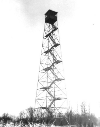 The structure at Gilbert Lake was an 80' Aermotor LS40 tower erected by
the CCC in 1934 for the Conservation Department's Division of State
Parks.
The structure at Gilbert Lake was an 80' Aermotor LS40 tower erected by
the CCC in 1934 for the Conservation Department's Division of State
Parks.  The
structure on Hooker Hill was a 79' 6" International Derrick E-4898
tower that was provided to the State of New York by the US Forest
Service and erected by the CCC Camp S-93, Breakabeen. The tower was
first operated in 1936 reporting 3 fires but no visitors. Hooker was
located 7 1/2 miles southeast of Cooperstown on the Hooker Hill State
Forest. The structure was removed by Dave Vana.
The
structure on Hooker Hill was a 79' 6" International Derrick E-4898
tower that was provided to the State of New York by the US Forest
Service and erected by the CCC Camp S-93, Breakabeen. The tower was
first operated in 1936 reporting 3 fires but no visitors. Hooker was
located 7 1/2 miles southeast of Cooperstown on the Hooker Hill State
Forest. The structure was removed by Dave Vana.

 Nimham
Mountain, named after Chief Daniel Nimham of the Wappingers tribe,
contains 1,023 acres in the town of Kent, Putnam County. The name was
recently changed from "Ninham" to "Nimham" to correct a long standing
spelling error.
Nimham
Mountain, named after Chief Daniel Nimham of the Wappingers tribe,
contains 1,023 acres in the town of Kent, Putnam County. The name was
recently changed from "Ninham" to "Nimham" to correct a long standing
spelling error.
 The
tower on Berlin Mountain was a 50' steel structure erected about1915 by
the State of Massachusetts This was one of two towers erectedto replace
the tower on Mt. Greylock which had poor visibility.
The
tower on Berlin Mountain was a 50' steel structure erected about1915 by
the State of Massachusetts This was one of two towers erectedto replace
the tower on Mt. Greylock which had poor visibility.  The
City of Troy subscribed $1,000 towards the expense of establishing this
tower. The City's interest in this station was that it covered the
forested area of the city watershed, which includes hundreds of acres
of plantations.
The
City of Troy subscribed $1,000 towards the expense of establishing this
tower. The City's interest in this station was that it covered the
forested area of the city watershed, which includes hundreds of acres
of plantations. 

 The
structure on Number Seven Hill was a 60' Aermotor LS40 tower erected by
the Conservation Commission in 1922 which became operational in 1923.
It was located on a hill identified as "Seven Hills" by the US
Geological Survey, 5 miles northwest of Stephentown and 5 miles
southeast of Averill Park.
The
structure on Number Seven Hill was a 60' Aermotor LS40 tower erected by
the Conservation Commission in 1922 which became operational in 1923.
It was located on a hill identified as "Seven Hills" by the US
Geological Survey, 5 miles northwest of Stephentown and 5 miles
southeast of Averill Park.
 The
structure on Jackie Jones is a 60' steel tower erected by the Palisades
State Park Commission on Bear Mt. State Park in 1928. It replaced a
wooden tower that stood there previously. The Conservation Department's
Bureau of Forest Fire Control took over operation of Jackie Jones Tower
in 1931.
The
structure on Jackie Jones is a 60' steel tower erected by the Palisades
State Park Commission on Bear Mt. State Park in 1928. It replaced a
wooden tower that stood there previously. The Conservation Department's
Bureau of Forest Fire Control took over operation of Jackie Jones Tower
in 1931.  The
structure on Leonard Hill is an 80' Aermotor LS40 tower erected by the
Conservation Department in 1948. The tower was previously at Gilbert
Lake State Park from 1932 until it was dismantled and moved in 1948.
It's currently found about 13 1/2 miles east of Stamford on the Leonard
Hill State Forest.
The
structure on Leonard Hill is an 80' Aermotor LS40 tower erected by the
Conservation Department in 1948. The tower was previously at Gilbert
Lake State Park from 1932 until it was dismantled and moved in 1948.
It's currently found about 13 1/2 miles east of Stamford on the Leonard
Hill State Forest.
 The
structure on Petersburg was a 67' 6" International Derrick tower
erected by CCC Camp S-93, Breakabeen, in 1940. The tower was first
staffed in 1941 reporting 7 fires and 223 visitors.
The
structure on Petersburg was a 67' 6" International Derrick tower
erected by CCC Camp S-93, Breakabeen, in 1940. The tower was first
staffed in 1941 reporting 7 fires and 223 visitors. 
 The
Sullivan Co Board of Supervisors appropriated money for an observation
station between Highland and Bethel on Chapin Hill. The structure, a
60' Aermotor LS40 tower, was completed early in the spring of 24 in
time for use throughout the 1924 season. It was located about 8 1/2
miles southwest of Monticello.
The
Sullivan Co Board of Supervisors appropriated money for an observation
station between Highland and Bethel on Chapin Hill. The structure, a
60' Aermotor LS40 tower, was completed early in the spring of 24 in
time for use throughout the 1924 season. It was located about 8 1/2
miles southwest of Monticello.

 The
structure at Roosa Gap was a 35' standard Aermotor tower erected by the
Conservation Department in 1948 in Sullivan Co on the Shawangunk Range
near Summitville.
The
structure at Roosa Gap was a 35' standard Aermotor tower erected by the
Conservation Department in 1948 in Sullivan Co on the Shawangunk Range
near Summitville.


 The
first tower was a 65' converted windmill on the property of Eugene E.
Howe of Griffin Corners (present-day Fleischmanns) that was taken over
by the Forest, Fish and Game Commission in 1909 and was one of the
first fire towers in New York State. It was located 2 miles west of
Pine Hill in Ulster County.
The
first tower was a 65' converted windmill on the property of Eugene E.
Howe of Griffin Corners (present-day Fleischmanns) that was taken over
by the Forest, Fish and Game Commission in 1909 and was one of the
first fire towers in New York State. It was located 2 miles west of
Pine Hill in Ulster County.  The
structure on Gallis was a 60' Aermotor LS40 tower, erected by the
Conservation Department in 1927. The first standard design for
observer's cabins was developed in 1922, mandating that they be
12’ x 16’ in size and roofed and sided with asphalt
shingles. A cabin of this design was erected at the same time as the
tower.
The
structure on Gallis was a 60' Aermotor LS40 tower, erected by the
Conservation Department in 1927. The first standard design for
observer's cabins was developed in 1922, mandating that they be
12’ x 16’ in size and roofed and sided with asphalt
shingles. A cabin of this design was erected at the same time as the
tower. The
first structure on High Point was a wooden tower erected by the
Conservation Commission in 1912. In 1919 it was replaced with a 47'
Aermotor LS40 tower erected by the Conservation Commission on the
northern shoulder of the mountain.
The
first structure on High Point was a wooden tower erected by the
Conservation Commission in 1912. In 1919 it was replaced with a 47'
Aermotor LS40 tower erected by the Conservation Commission on the
northern shoulder of the mountain.
 The
first structure here was a wooden tower erected in 1912 by the
Conservation Commission on Dickie Bar Ridge, to the west of the Coxing
Kill, on a height of land just a mile northeast of the Hamlet of
Minnewaska.
The
first structure here was a wooden tower erected in 1912 by the
Conservation Commission on Dickie Bar Ridge, to the west of the Coxing
Kill, on a height of land just a mile northeast of the Hamlet of
Minnewaska.  Overlook
is a standard 60' Aermotor LS40 tower that was first erected on Gallis
Hill in 1927. It was taken down by the Conservation Department and
moved to this location in 1950. It's located about 3 1/4 miles north of
Woodstock on New York State Forest Preserve lands in the Overlook Mt.
Wild Forest.
Overlook
is a standard 60' Aermotor LS40 tower that was first erected on Gallis
Hill in 1927. It was taken down by the Conservation Department and
moved to this location in 1950. It's located about 3 1/4 miles north of
Woodstock on New York State Forest Preserve lands in the Overlook Mt.
Wild Forest.
 The
structure on Red Hill is a 60' Aermotor LS40 tower erected by the
Conservation Commission in 1920.
A new two-way radio was installed in this tower and licensed as W10XIE
in 1938, and was only the second tower in New York State to be radio
equipped.
The
structure on Red Hill is a 60' Aermotor LS40 tower erected by the
Conservation Commission in 1920.
A new two-way radio was installed in this tower and licensed as W10XIE
in 1938, and was only the second tower in New York State to be radio
equipped.


 The
first structure on Slide was a wooden tower, but it is unclear as to
whether it was erected by the Conservation Commission or if it
previously existed. The tower on Slide Mt. was operational for just one
year - 1912. The site was deemed unsuitable for fire detection purposes
and closed. The tower was "officially" closed in 1916.
The
first structure on Slide was a wooden tower, but it is unclear as to
whether it was erected by the Conservation Commission or if it
previously existed. The tower on Slide Mt. was operational for just one
year - 1912. The site was deemed unsuitable for fire detection purposes
and closed. The tower was "officially" closed in 1916.  The
structure on Tremper, a 47' Aermotor LS40 tower, was begun in late 1916
and completed in 1917 by the Conservation Commission. The tower on
Tremper was built to replace the one previously on Slide Mt. It's
located just 2 miles east of Phoenicia on New York State Forest
Preserve lands in the Phoenicia-Mt. Tobias Wild Forest.
The
structure on Tremper, a 47' Aermotor LS40 tower, was begun in late 1916
and completed in 1917 by the Conservation Commission. The tower on
Tremper was built to replace the one previously on Slide Mt. It's
located just 2 miles east of Phoenicia on New York State Forest
Preserve lands in the Phoenicia-Mt. Tobias Wild Forest.

 The
structure on Cross River was a 60' Aermotor LS40 tower erected by
Westchester County Park Commission, a former Region in the Division of
Parks, on the Pound Ridge Reservation in 1926. The Conservation
Department took over operation of the tower in 1931.
The
structure on Cross River was a 60' Aermotor LS40 tower erected by
Westchester County Park Commission, a former Region in the Division of
Parks, on the Pound Ridge Reservation in 1926. The Conservation
Department took over operation of the tower in 1931. 


 When
this observation station was established in April 1910, no tower was
immediately erected due to the lack of tree cover on the mountaintop
from prior use as a Colvin triangulation station. There is no evidence
that a tower was ever built on Lyon until 1917 when the Conservation
Commission erected a 35' Aermotor LS40 tower.
When
this observation station was established in April 1910, no tower was
immediately erected due to the lack of tree cover on the mountaintop
from prior use as a Colvin triangulation station. There is no evidence
that a tower was ever built on Lyon until 1917 when the Conservation
Commission erected a 35' Aermotor LS40 tower.
 In 2005,
Domtar industries sold 20,000 acres of its holdings around Lyon Mt. to
The Nature Conservancy (TNC) for eventual re-sale to New York State,
and a new trail to the summit was constructed. FFLA is the maintainer
of the trail and fire tower.
In 2005,
Domtar industries sold 20,000 acres of its holdings around Lyon Mt. to
The Nature Conservancy (TNC) for eventual re-sale to New York State,
and a new trail to the summit was constructed. FFLA is the maintainer
of the trail and fire tower.  A
60' Aermotor LS40 tower and observers cabin were erected by the
Conservation Department in 1930 and operated for a portion of that
season reporting 9 fires. This tower was intended to supplement
Whiteface Mt. It is located in an area where early spring and late fall
fires are a frequent occurrence, and because of the inability to
operate Whiteface Mountain tower during those periods, the fires were
frequently large in size before being reported by some other more
remote tower.
A
60' Aermotor LS40 tower and observers cabin were erected by the
Conservation Department in 1930 and operated for a portion of that
season reporting 9 fires. This tower was intended to supplement
Whiteface Mt. It is located in an area where early spring and late fall
fires are a frequent occurrence, and because of the inability to
operate Whiteface Mountain tower during those periods, the fires were
frequently large in size before being reported by some other more
remote tower.
 The
first structure up on Adams was a wooden tower constructed by the
Conservation Commission in 1912. In 1917, the Conservation Commission
replaced it with a 47' steel Aermotor LS40 tower.
The
first structure up on Adams was a wooden tower constructed by the
Conservation Commission in 1912. In 1917, the Conservation Commission
replaced it with a 47' steel Aermotor LS40 tower. 


 The
first structure on Belfry was a wooden tower constructed by the
Conservation Commission in 1912. In 1917, the Commission replaced the
wooden tower with a 47' Aermotor LS40 tower.
The
first structure on Belfry was a wooden tower constructed by the
Conservation Commission in 1912. In 1917, the Commission replaced the
wooden tower with a 47' Aermotor LS40 tower.  The
first structure on Boreas was a wooden tower constructed by the
Conservation Commission in May 1911. In 1919, the Conservation
Commission replaced the wooden tower with a 47' LS40 Aermotor tower.
The
first structure on Boreas was a wooden tower constructed by the
Conservation Commission in May 1911. In 1919, the Conservation
Commission replaced the wooden tower with a 47' LS40 Aermotor tower.

 Goodnow
Mt. was chosen as an ideal site for an observation station in the town
of Newcomb, Essex county, in 1921. A steel tower had been secured
through extensive cooperation of landowners and lumbermen operating in
the area in hopes to have it operational in 1922.
Goodnow
Mt. was chosen as an ideal site for an observation station in the town
of Newcomb, Essex county, in 1921. A steel tower had been secured
through extensive cooperation of landowners and lumbermen operating in
the area in hopes to have it operational in 1922.  When
this observation station was established in April 1910, no tower was
immediately erected, as an unobstructed view was available due to the
lack of tree cover on the mountaintop. There is currently no evidence
that a tower was ever built on Hurricane until 1919 when the
Conservation Commission erected a 35' Aermotor LS40 tower.
When
this observation station was established in April 1910, no tower was
immediately erected, as an unobstructed view was available due to the
lack of tree cover on the mountaintop. There is currently no evidence
that a tower was ever built on Hurricane until 1919 when the
Conservation Commission erected a 35' Aermotor LS40 tower. 
 The
first structure on Makomis Mt. was a fully enclosed wooden tower taken
over by the Conservation Commission in September 1911. It's doubtful
that the Conservation Department actually built the structure. In 1916
it was replaced with a 40' Aermotor LL25 tower. It was of a lighter
weight than their 1917 design and had no stairs but only a ladder up
the exterior for the purpose of ingress and egress. Wooden steps were
added within the structure to ease access for both the Observer and the
general public in 1918 or 1919. (
The
first structure on Makomis Mt. was a fully enclosed wooden tower taken
over by the Conservation Commission in September 1911. It's doubtful
that the Conservation Department actually built the structure. In 1916
it was replaced with a 40' Aermotor LL25 tower. It was of a lighter
weight than their 1917 design and had no stairs but only a ladder up
the exterior for the purpose of ingress and egress. Wooden steps were
added within the structure to ease access for both the Observer and the
general public in 1918 or 1919. (
 When
this observation station was established in April 1910, no tower was
immediately erected, as an unobstructed view was available due to the
lack of tree cover on the mountaintop. The first structure on Pharaoh
Mt. was a little more than a pole frame with a canvas tarp where the
observer could get in out of the weather.
When
this observation station was established in April 1910, no tower was
immediately erected, as an unobstructed view was available due to the
lack of tree cover on the mountaintop. The first structure on Pharaoh
Mt. was a little more than a pole frame with a canvas tarp where the
observer could get in out of the weather.
.jpg - 42324 Bytes")
 The first structure on Poke-O-Moonshine was a wooden tower erected by the Conservation Commission in 1912.
In 1917 the wood tower was replaced with a 35' Aermotor tower.
The first structure on Poke-O-Moonshine was a wooden tower erected by the Conservation Commission in 1912.
In 1917 the wood tower was replaced with a 35' Aermotor tower.

")

 The
first structure on Vanderwhacker was a wooden tower erected by the
Conservation Commission in May 1911. In 1918 it was replaced with a 35'
Aermotor LS40 tower.
The
first structure on Vanderwhacker was a wooden tower erected by the
Conservation Commission in May 1911. In 1918 it was replaced with a 35'
Aermotor LS40 tower.


 The
observation station was established on Ampersand in August 1911 though
no tower was initially erected. The first structure on Ampersand was a
stone hut or cabin for the observer. In 1920, a 22' steel Aermotor LS40
tower was purchased for this site and was erected in 1921.
The
observation station was established on Ampersand in August 1911 though
no tower was initially erected. The first structure on Ampersand was a
stone hut or cabin for the observer. In 1920, a 22' steel Aermotor LS40
tower was purchased for this site and was erected in 1921. 

 The
first structure on Azure was a wooden tower constructed by the
Conservation Commission in 1914. In 1918, the Conservation Commission
replaced it with a 35' Aermotor LS40 tower.
The
first structure on Azure was a wooden tower constructed by the
Conservation Commission in 1914. In 1918, the Conservation Commission
replaced it with a 35' Aermotor LS40 tower.
.jpg - 57496 Bytes")


 The
first structure on Loon Lake was a wooden tower erected by the
Conservation Commission in 1912. In 1917 it was replaced with a 35'
Aermotor LS40 tower.
The
first structure on Loon Lake was a wooden tower erected by the
Conservation Commission in 1912. In 1917 it was replaced with a 35'
Aermotor LS40 tower.

 Meenahga
Mt. is a privately owned tower that cooperated with the Conservation
Department towers during periods of high fire danger.
Meenahga
Mt. is a privately owned tower that cooperated with the Conservation
Department towers during periods of high fire danger.  When
this observation station was established in July 1909, no tower was
immediately erected, as an unobstructed view was available due to the
lack of tree cover on the mountaintop. In 1919, the wooden tower was
replaced with a 22' Aermotor LS40 tower, which was purchased the
previous year.
When
this observation station was established in July 1909, no tower was
immediately erected, as an unobstructed view was available due to the
lack of tree cover on the mountaintop. In 1919, the wooden tower was
replaced with a 22' Aermotor LS40 tower, which was purchased the
previous year. 
 When
this observation station was established in April 1910, no tower was
immediately erected, as an unobstructed view was available due to the
lack of tree cover on the mountaintop. There is no evidence that a
tower was ever built on St. Regis until 1918, when the Conservation
Commission erected a 35' Aermotor LS40 tower.
When
this observation station was established in April 1910, no tower was
immediately erected, as an unobstructed view was available due to the
lack of tree cover on the mountaintop. There is no evidence that a
tower was ever built on St. Regis until 1918, when the Conservation
Commission erected a 35' Aermotor LS40 tower. 
.jpg - 95008 Bytes") The structure is a 60' Aermotor LS40 tower constructed by the Conservation Commission in 1925.
The structure is a 60' Aermotor LS40 tower constructed by the Conservation Commission in 1925.
 This
tower ceased operation at the end of the 1988 season. The tower was
officially closed in early 1989 when the Department of Environmental
Conservation determined that towers were no longer effective and
decided to phase them out of service.
This
tower ceased operation at the end of the 1988 season. The tower was
officially closed in early 1989 when the Department of Environmental
Conservation determined that towers were no longer effective and
decided to phase them out of service.
 The
tower has been restored and is maintained by the Canada Lakes
Protective Assn. and FFLA. It is open to the public. Kane Mt. now appears on the
The
tower has been restored and is maintained by the Canada Lakes
Protective Assn. and FFLA. It is open to the public. Kane Mt. now appears on the

 The
first structure on Blue Mt was a wooden tower, about 30' in height,
constructed by the Conservation Commission in September 1911. In 1917,
the Conservation Commission replaced the wooden tower with a 35'
Aermotor LS40 tower.
The
first structure on Blue Mt was a wooden tower, about 30' in height,
constructed by the Conservation Commission in September 1911. In 1917,
the Conservation Commission replaced the wooden tower with a 35'
Aermotor LS40 tower.


 The
first structure on Cathead Mt. was an 18' wooden tower constructed in
June 1910 by the Forest, Fish and Game Commission. Two and three
quarter miles of telephone line was constructed so that the observer
could quickly report fires spotted to the local Fire Patrolman/Forest
Ranger.
The
first structure on Cathead Mt. was an 18' wooden tower constructed in
June 1910 by the Forest, Fish and Game Commission. Two and three
quarter miles of telephone line was constructed so that the observer
could quickly report fires spotted to the local Fire Patrolman/Forest
Ranger.  In
1929, Aermotor developed a self-supporting staircase for installation
in the towers purchased in 1916. This staircase amounted to a tower
within a tower and was anchored to the original tower. These were
purchased to replace the wooden stairs currently in use and was
installed in this tower in 1929.
In
1929, Aermotor developed a self-supporting staircase for installation
in the towers purchased in 1916. This staircase amounted to a tower
within a tower and was anchored to the original tower. These were
purchased to replace the wooden stairs currently in use and was
installed in this tower in 1929.
 This
tower ceased operation at the end of the 1988 season. The tower was
officially closed in early 1989 when the Department of Environmental
Conservation determined that towers were no longer effective and
decided to phase them out of service.
This
tower ceased operation at the end of the 1988 season. The tower was
officially closed in early 1989 when the Department of Environmental
Conservation determined that towers were no longer effective and
decided to phase them out of service.

 The
first structure on Hamilton Mt. was an 18' wooden tower constructed in
October 1909 by the Forest, Fish and Game Commission. In 1916 it was
replaced with a 50' Aermotor LL25 tower. It was of a lighter weight
than their 1917 design and had no stairs but only a ladder up the
The
first structure on Hamilton Mt. was an 18' wooden tower constructed in
October 1909 by the Forest, Fish and Game Commission. In 1916 it was
replaced with a 50' Aermotor LL25 tower. It was of a lighter weight
than their 1917 design and had no stairs but only a ladder up the
 The
first structure on Kempshall was a wooden tower erected by the
Conservation Commission in May 1911. In 1918 the wooden tower was
replaced with a 35' Aermotor LS40 tower.
The
first structure on Kempshall was a wooden tower erected by the
Conservation Commission in May 1911. In 1918 the wooden tower was
replaced with a 35' Aermotor LS40 tower. 


 The first structure on Pillsbury was a wooden tower erected by the Champlain Realty Co in 1918.


 Salmon
Lake Mt. was a privately owned tower that cooperated with the
Conservation Department towers during periods of high fire danger. The
structure on Salmon Lake is a 35' Aermotor LX24 tower erected by
Whitney Park about 1933.
Salmon
Lake Mt. was a privately owned tower that cooperated with the
Conservation Department towers during periods of high fire danger. The
structure on Salmon Lake is a 35' Aermotor LX24 tower erected by
Whitney Park about 1933.  The
first structure on Snowy was a wooden tower erected by the Forest, Fish
& Game Commission in August 1909. In 1917 it was replaced with a
22' Aermotor LS40 tower.
The
first structure on Snowy was a wooden tower erected by the Forest, Fish
& Game Commission in August 1909. In 1917 it was replaced with a
22' Aermotor LS40 tower. 

.jpg - 85959 Bytes")
 In
1916 the Conservation Commission erected a 50' Aermotor LL25 tower. It
was of a lighter weight than their 1917 design and had no stairs but
only a ladder up the exterior for the purpose of ingress and egress.
Wooden steps were added within the structure to ease access for both
the Observer and the general public in 1918 or 1919. (
In
1916 the Conservation Commission erected a 50' Aermotor LL25 tower. It
was of a lighter weight than their 1917 design and had no stairs but
only a ladder up the exterior for the purpose of ingress and egress.
Wooden steps were added within the structure to ease access for both
the Observer and the general public in 1918 or 1919. (

 The
first structure on Tomany Mt. was a wooden tower constructed by the
Conservation Commission in 1912. In 1916 the Conservation Commission
erected a 50' Aermotor LL25 tower. It was of a lighter weight than
their 1917 design and had no stairs but only a ladder
The
first structure on Tomany Mt. was a wooden tower constructed by the
Conservation Commission in 1912. In 1916 the Conservation Commission
erected a 50' Aermotor LL25 tower. It was of a lighter weight than
their 1917 design and had no stairs but only a ladder  up the exterior for the purpose of ingress and egress. Wooden steps
were added within the structure to ease access for both the Observer
and the general public in 1918 or 1919. (
up the exterior for the purpose of ingress and egress. Wooden steps
were added within the structure to ease access for both the Observer
and the general public in 1918 or 1919. (

 The
first structure on Wakely Mt. was a wooden tower constructed by the
Conservation Commission in May 1911. In 1916 it was replaced with a 70'
Aermotor LL25 tower. It was of a lighter weight than their 1917 design
and had no stairs but only a ladder up the exterior for the purpose of
ingress and egress.
The
first structure on Wakely Mt. was a wooden tower constructed by the
Conservation Commission in May 1911. In 1916 it was replaced with a 70'
Aermotor LL25 tower. It was of a lighter weight than their 1917 design
and had no stairs but only a ladder up the exterior for the purpose of
ingress and egress.  This tower appears on the


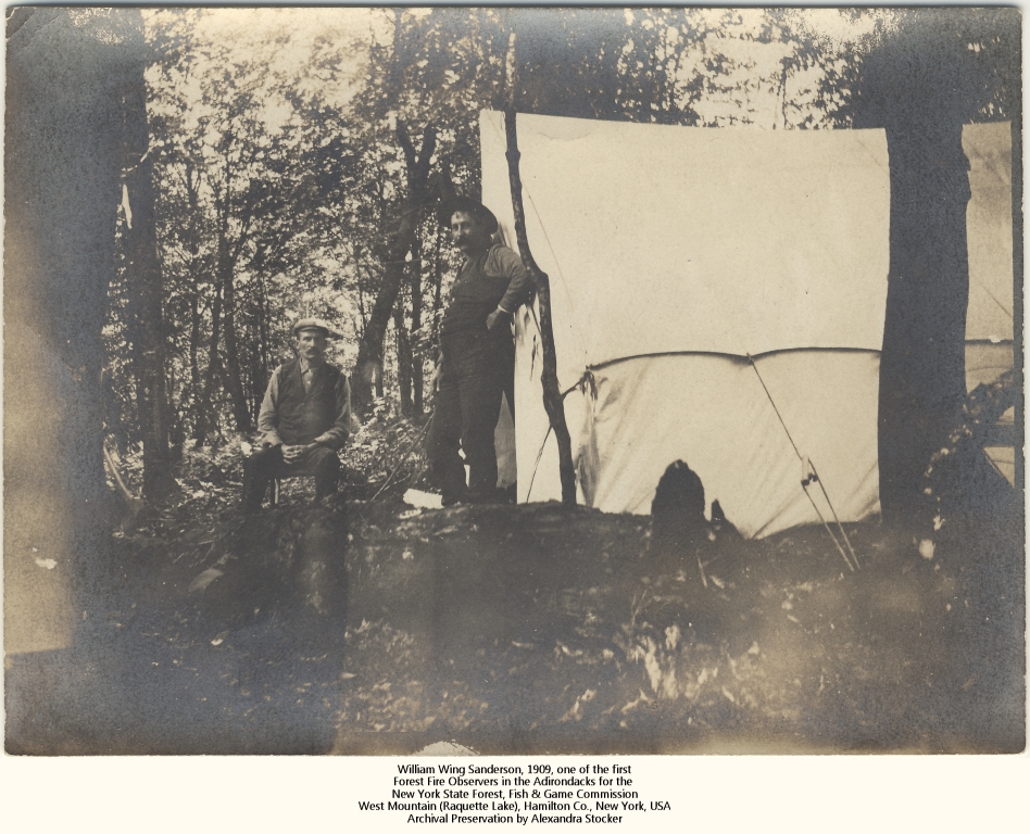

 Originally, the
Board of Supervisors of Saratoga County appropriated
the sum of $1,000 to be used for the establishment of a fire
observation station on Cornell Hill located about 2 miles southeast of
Saratoga Lake. Additional funds were contributed by a local landowner
to defray the expense of putting up the tower, the cabin and building
the necessary telephone line.
Originally, the
Board of Supervisors of Saratoga County appropriated
the sum of $1,000 to be used for the establishment of a fire
observation station on Cornell Hill located about 2 miles southeast of
Saratoga Lake. Additional funds were contributed by a local landowner
to defray the expense of putting up the tower, the cabin and building
the necessary telephone line.  Plans
for a tower on Hadley Mt. were made in 1916 when satisfactory
arrangements could not be made for the continuance of Ohmer Mt. Hadley
is 4 3/4 miles northeast of Ohmer Mt. The Conservation Commission
purchased in 1916 and installed in 1917, a 50' Aermotor LL25 tower. It
was of a lightweight design and had no stairs but only a ladder up the
exterior for the purposes of ingress and egress. Wooden steps were added
within the structure to ease access for both the Observer and the
general public. (
Plans
for a tower on Hadley Mt. were made in 1916 when satisfactory
arrangements could not be made for the continuance of Ohmer Mt. Hadley
is 4 3/4 miles northeast of Ohmer Mt. The Conservation Commission
purchased in 1916 and installed in 1917, a 50' Aermotor LL25 tower. It
was of a lightweight design and had no stairs but only a ladder up the
exterior for the purposes of ingress and egress. Wooden steps were added
within the structure to ease access for both the Observer and the
general public. (

 Through
funds made available by the International Paper Company, the City of Amsterdam and Saratoga County, the 73' Aermotor LS40 tower was erected by the Conservation Department during the summer of 1928.
Through
funds made available by the International Paper Company, the City of Amsterdam and Saratoga County, the 73' Aermotor LS40 tower was erected by the Conservation Department during the summer of 1928. 
 The
first structure on Crane was a wooden tower constructed by the
Conservation Commission in September 1911. In 1918 the Conservation
Commission purchased a 35' Aermotor LS40 tower that was erected on this
site in 1919.
The
first structure on Crane was a wooden tower constructed by the
Conservation Commission in September 1911. In 1918 the Conservation
Commission purchased a 35' Aermotor LS40 tower that was erected on this
site in 1919.
 The
first structure on Gore was an 18' wooden tower constructed by the
Forest, Fish and Game Commission in August 1909. In 1918 it was
replaced with a 60' Aermotor LS40 tower erected by the Conservation
Commission.
The
first structure on Gore was an 18' wooden tower constructed by the
Forest, Fish and Game Commission in August 1909. In 1918 it was
replaced with a 60' Aermotor LS40 tower erected by the Conservation
Commission. 
 The
Forest, Fish & Game Commission, first established the 35' wooden
fire observation tower in July 1910. Extensive repairs and a new roof
were made to the old hotel building and it became the headquarters for the
observer who used a cupola in the mountain top hotel for the
observation station.
The
Forest, Fish & Game Commission, first established the 35' wooden
fire observation tower in July 1910. Extensive repairs and a new roof
were made to the old hotel building and it became the headquarters for the
observer who used a cupola in the mountain top hotel for the
observation station. 

 The first structure on Swede was a wooden tower erected by the Conservation Commission in 1912. In 1918 it was replaced with a 47' Aermotor LS40 tower.
 The
structure on Colfax is an 80' Aermotor LS40 tower erected by the
Conservation Department in 1950. This tower was placed in service in
1951 reporting 23 fires and 750 visitors.
The
structure on Colfax is an 80' Aermotor LS40 tower erected by the
Conservation Department in 1950. This tower was placed in service in
1951 reporting 23 fires and 750 visitors.

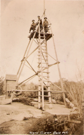
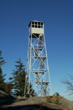
")
 The
first structure on Beaver Lake Mt was a wooden tower constructed by the
Conservation Commission on the lands of the Fisher Forestry and Reality
Co. about 1915. In 1919, a 47' Aermotor LS40 tower was purchased and
erected on the site in 1920.
The
first structure on Beaver Lake Mt was a wooden tower constructed by the
Conservation Commission on the lands of the Fisher Forestry and Reality
Co. about 1915. In 1919, a 47' Aermotor LS40 tower was purchased and
erected on the site in 1920.


 With the advent of aerial detection, this tower was closed at the end of the 1970 season.


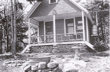


 The
structure on Gomer Hill was a 67' 6" International Derrick tower
erected by the CCC Camp S-122, Boonville in 1940. The tower was first
staffed in 1941 reporting 2 fires and 161 visitors.
The
structure on Gomer Hill was a 67' 6" International Derrick tower
erected by the CCC Camp S-122, Boonville in 1940. The tower was first
staffed in 1941 reporting 2 fires and 161 visitors.

 The structure on New Boston was an 80' Aermotor LS40 tower erected by the Conservation Department in 1950.


 The
tower finally became property of the State in the late 1950's. The
parcel of land, containing 4.3 acres, which including both the cabin
and tower, was transferred from Fisher Forestry & Realty Co. to the
State of New York in 1958. Up until that time, it was a privately owned
tower, first operated by the landowner for ten years and then by the
State for the remaining time.
The
tower finally became property of the State in the late 1950's. The
parcel of land, containing 4.3 acres, which including both the cabin
and tower, was transferred from Fisher Forestry & Realty Co. to the
State of New York in 1958. Up until that time, it was a privately owned
tower, first operated by the landowner for ten years and then by the
State for the remaining time.
 The
structure on Swancott was a 99' 9" International Derrick tower erected
by CCC Camp S-113, Camden in 1940.
The
structure on Swancott was a 99' 9" International Derrick tower erected
by CCC Camp S-113, Camden in 1940.

 The
structure on Penn was an 80' Aermotor LS40 tower erected by the
Conservation Department in 1950. This tower was placed in service in
1951 reporting no fires and only 4 visitors.
The
structure on Penn was an 80' Aermotor LS40 tower erected by the
Conservation Department in 1950. This tower was placed in service in
1951 reporting no fires and only 4 visitors.
 The structure on Castor Hill was an 80' Aermotor LS40 tower erected by the Conservation Department in 1927.
 The
first structure on Arab Mt. was a wooden tower constructed by the
Conservation Commission in September 1911. In 1918, the Conservation
Commission replaced it with a 35' Aermotor LS40 tower.
The
first structure on Arab Mt. was a wooden tower constructed by the
Conservation Commission in September 1911. In 1918, the Conservation
Commission replaced it with a 35' Aermotor LS40 tower. 
.jpg - 28691 Bytes") The
first structure on Cat was a 37' wooden tower constructed by the
Forest, Fish and Game Commission in July 1910. In 1917, the
Conservation Commission replaced it with a 47' Aermotor LS40 tower.
The
first structure on Cat was a 37' wooden tower constructed by the
Forest, Fish and Game Commission in July 1910. In 1917, the
Conservation Commission replaced it with a 47' Aermotor LS40 tower. 
 The
first structure on Catamount was a wooden tower constructed by the
Conservation Commission in October 1911. In 1917 the Conservation
Commission replaced the wooden tower with a 35' Aermotor LS40 tower.
The
first structure on Catamount was a wooden tower constructed by the
Conservation Commission in October 1911. In 1917 the Conservation
Commission replaced the wooden tower with a 35' Aermotor LS40 tower.
 The first structure on Moosehead was a 20' wooden tower erected by the Forest, Fish and Game Commission in June 1910. In 1916 it was replaced with a 40' Aermotor LL25 tower.
It was of a lighter weight than their 1917 design and had no stairs but only a ladder up the exterior for the purpose of ingress and egress. Wooden steps were added within the
structure to ease access for both the Observer and the general public in 1918 or 1919.
The first structure on Moosehead was a 20' wooden tower erected by the Forest, Fish and Game Commission in June 1910. In 1916 it was replaced with a 40' Aermotor LL25 tower.
It was of a lighter weight than their 1917 design and had no stairs but only a ladder up the exterior for the purpose of ingress and egress. Wooden steps were added within the
structure to ease access for both the Observer and the general public in 1918 or 1919. 

 The
first structure on Tooley Pond was a wooden tower erected by the
Conservation Commission in 1913. In 1919 it was replaced with a 47'
Aermotor LS40 tower.
The
first structure on Tooley Pond was a wooden tower erected by the
Conservation Commission in 1913. In 1919 it was replaced with a 47'
Aermotor LS40 tower. 
 The
structure on Whites Hill was an 80' Aermotor LS40 tower erected by the
Conservation Department in 1950. This tower was placed in service in
1951 reporting 3 fires and 588 visitors.
The
structure on Whites Hill was an 80' Aermotor LS40 tower erected by the
Conservation Department in 1950. This tower was placed in service in
1951 reporting 3 fires and 588 visitors. 
 Location: 3 miles northeast of the Village of Alma.
  Many of these towers were only staffed on an as-needed basis by other Division of Lands and Forests personnel.
 Location: 3 1/2 miles north of West Almond.
 Location: 2 miles south of Binghamton.
 Location: 7 miles northwest of Deposit.
 Location: Allegany State Park - Above the ski area on the western slope of Bova Mt.
  Location: 4 miles south of Olean.


 Location: In Allegany State Park
  Location: On the Allegany Indian Reservation 3 miles southwest of the City of Salamanca.
  The stenciling on the steel brace shows the location to where the tower was originally shipped.
 Location:Southwest of the Bradford Entrance near the Pennsylvania border.
  Location: In the Allegany State Park, 2 miles south of Salamanca.
 The Fire Tower Restoration Committee, a part of the Allegany State Park Historical Society was formed in 1999. The
 Location: About 1 mile East of East Pharsalia, on North Tower Road.
 Location: 4 miles east of Norwich on the south side of State Rt. 23
 Location: 3 1/2 miles north of Truxton.
 Location: 5 miles southwest of the Hamlet of Brookfield.
 Location: 3 1/2 miles north of the Village of Georgetown.
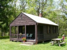 Sugar Hill Observer's Cabin - 2004 - A Warren Johnsen Photo">It appears on the
 Location: 2 miles northwest of the Village of Prattsburg.
 Location: 12 miles southeast of Ithaca.
.jpg "Padlock Hill Fire Tower at NYS Fair Grounds align=")
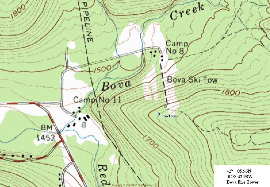
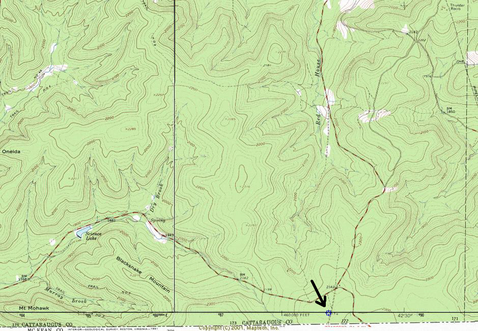